
Glandage
| Glandage | ||
|---|---|---|
|
||
| region | Auvergne-Rhône-Alpes | |
| Department | Drôme | |
| Arrondissement | The | |
| Canton | De Diois | |
| Community association | Diois | |
| Coordinates | 44 ° 41 ′ N , 5 ° 36 ′ E | |
| height | 71–2,045 m | |
| surface | 52.11 km 2 | |
| Residents | 113 (January 1, 2017) | |
| Population density | 2 inhabitants / km 2 | |
| Post Code | 26410 | |
| INSEE code | 26142 | |

Glandage is a French municipality with 113 inhabitants (at January 1, 2017) in the Drome region, in the region of Auvergne Rhône-Alpes . It belongs to the canton of Le Diois and the arrondissement of Die . It borders Treschenu-Creyers to the west and northwest , Saint-Maurice-en-Trièves and Lalley to the northeast, Lus-la-Croix-Haute to the east, Saint-Julien-en-Beauchêne to the southeast and Saint-Julien-en-Beauchêne to the south Boulc .
geography
The former Route nationale 539 leads over Glandage.

Glandage is located in the Vercors Regional Nature Park . The picture shows the Gorge des Gats.
Population development
| year | 1962 | 1968 | 1975 | 1982 | 1990 | 1999 | 2008 | 2016 |
|---|---|---|---|---|---|---|---|---|
| Residents | 123 | 99 | 82 | 121 | 111 | 84 | 93 | 113 |
Attractions
- Saints Pierre et Paul Church, Monument historique
- Fallen memorial
- Chapel in the hamlet of Grimone
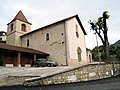
Church of St. Peter and Paul
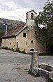
Chapel in the hamlet of Grimone


Web links
Commons : Glandage - collection of images, videos and audio files