Mornans
| Mornans | ||
|---|---|---|
|
|
||
| region | Auvergne-Rhône-Alpes | |
| Department | Drôme | |
| Arrondissement | The | |
| Canton | Dieulefit | |
| Community association | Val de Drôme | |
| Coordinates | 44 ° 37 ' N , 5 ° 8' E | |
| height | 339-1,307 m | |
| surface | 11.72 km 2 | |
| Residents | 72 (January 1, 2017) | |
| Population density | 6 inhabitants / km 2 | |
| Post Code | 26460 | |
| INSEE code | 26214 | |
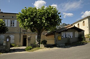
 Mairie Mornans |
||
Mornans is a French commune in the department of Drôme in the region Auvergne Rhône-Alpes .
geography
The municipality of Mornans has an area of 11.72 km² and covers a section of the French Alpine Foreland. The village settlement lies in a wide valley, formed by the Roubion , a tributary of the Rhône . At 1307 meters, the highest point is the top of the Saou mountain range in the north of the municipality. Mornans is located 2.3 km north of Bourdeaux , approx. 16 km southeast of Crest and almost 30 km east of Montélimar (as the crow flies).
Population development
| year | 1968 | 1975 | 1982 | 1990 | 1999 | 2004 | 2016 |
| Residents | 64 | 62 | 78 | 68 | 53 | 61 | 70 |
With 72 inhabitants (as of January 1, 2017), Mornans is one of the smaller communities in the Drôme department. In 1962 the community still had 77 residents. After the population had steadily decreased until 1975, growth was recorded in the late 1970s.
Culture and sights
- Tour de Mornans , castle ruins from the 13th century
- Protestant village church
- Numerous signposted hiking trails
