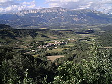
Barnave
| Barnave | ||
|---|---|---|
|
|
||
| region | Auvergne-Rhône-Alpes | |
| Department | Drôme | |
| Arrondissement | The | |
| Canton | Le Diois | |
| Community association | Diois | |
| Coordinates | ||
| height | 474-1,340 m | |
| surface | 13.06 km 2 | |
| Residents | 198 (January 1, 2017) | |
| Population density | 15 inhabitants / km 2 | |
| Post Code | 26310 | |
| INSEE code | 26025 | |
 Mairie and School in Barnave |
||
Barnave is a French commune in the department of Drôme in the region Auvergne Rhône-Alpes . It belongs to the Arrondissement Die , the canton Le Diois and the local authority association Diois, founded in 2001 .
geography
The community of Barnave, with 198 inhabitants (January 1, 2017), is located in the natural landscape and historical region of Diois , about 13 kilometers south of Die in a side valley of the Drôme , a tributary of the Rhône . In the northeast, the municipality of Barnave has a small part of the Drômetal. The valley of the Barnavette, which runs in a west-east direction . Barnave is located in, is flanked in the north, west and south by mountain ridges that exceed 800 m in the north and 1000 m in the west and south. The highest point in the south-west is La Pâle, at 1340 m above sea level. Barnave's neighboring municipalities are Montmaur-en-Diois in the north, Saint-Roman and Menglon in the northeast, Recoubeau-Jansac in the east, Aucelon in the south, Pennes-le-Sec in the southwest and Rimon-et-Savel in the west.
history
The first mention of Barnave comes from 1227 as Barnava . It is believed that the name is a mixture of Celtic and Gallic roots and means something like height above a steep valley .
Population development
| year | 1962 | 1968 | 1975 | 1982 | 1990 | 1999 | 2006 | 2017 | |
| Residents | 143 | 117 | 109 | 119 | 125 | 155 | 156 | 198 | |
| Sources: Cassini and INSEE | |||||||||
Attractions
- Catholic Church of the Assumption ( Église Notre-Dame-de-l'Assomption )
- protestant church
Economy and Infrastructure
The main occupation in Barnave is viticulture. In Barnave, grapes of the varieties Gelber Muskateller and Clairette Blanche grow on the south-facing slopes . The vines in Barnave are part of the Clairette de Die - appellation for sparkling wines . 19 farms are located in the municipality (including 14 winegrowers, as well as grain cultivation, goat and sheep breeding).
In the north-east of Barnave the trunk road runs from Crest via Die to Gap or to Sisteron . A road connection leads over the 1040 m high Col de Pennes in a south-westerly direction. The nearest train stations are in Die and Luc-en-Diois on the Livron - Aspres-sur-Buëch line .
supporting documents
- ↑ Archive link ( Memento of the original from October 22, 2013 in the Internet Archive ) Info: The archive link was inserted automatically and has not yet been checked. Please check the original and archive link according to the instructions and then remove this notice. Origin of the name on monsaintegreve.expertpublic.fr/ (French)
- ↑ Barnave on cassini.ehess.fr
- ↑ Barnave on insee.fr
- ↑ Farms on annuaire-mairie.fr (French)

