
Vassieux-en-Vercors
| Vassieux-en-Vercors | ||
|---|---|---|
.svg)
|
|
|
| region | Auvergne-Rhône-Alpes | |
| Department | Drôme | |
| Arrondissement | The | |
| Canton | Vercors-Monts du Matin | |
| Community association | Sisteronais-Buëch | |
| Coordinates | 44 ° 56 ' N , 5 ° 26' E | |
| height | 1,028-1,654 m | |
| surface | 48.25 km 2 | |
| Residents | 313 (January 1, 2017) | |
| Population density | 6 inhabitants / km 2 | |
| Post Code | 26420 | |
| INSEE code | 26364 | |
| Website | http://www.vassieuxenvercors.fr/ | |
 Town hall (Mairie) of Vassieux-en-Vercors |
||

Vassieux-en-Vercors is a French municipality with 313 inhabitants (as of January 1 2017) in the department of Drôme in the region Auvergne Rhône-Alpes (before 2016: Rhône-Alpes ); it belongs to the arrondissement of Die and the canton of Vercors-Monts du Matin (until 2015: canton of La Chapelle-en-Vercors ). The inhabitants are called Vassiveins .
history
Vassieux-en-Vercors is home to several prehistoric archaeological sites and has a museum of prehistory that was established in May 1970 after the discovery of a flint cutting workshop.
In June and July 1944, during World War II, the French resistance known as the Maquis du Vercors carried out a major uprising against the German occupation in Vercors and proclaimed the Free Republic of Vercors. It was the first democratic area in France since the beginning of the German occupation in 1940 - the uprising was brutally suppressed. The city was awarded the Ordre de la Liberation for its major resistance actions. At Col de la Chau 44.90760 ° N 5.36124 ° E, a memorial was built to commemorate the terrible events of World War II, including a cemetery where the victims of a German massacre in July 1944 are buried.
geography
Vassieux-en-Vercors is about 38 kilometers east-southeast of Valence . Vassieux-en-Vercors is surrounded by the neighboring municipalities of La Chapelle-en-Vercors in the north, Saint-Agnan-en-Vercors in the east and northeast, Chamaloc in the southeast, Marignac-en-Diois in the south, and Saint-Julien-en-Quint in the south-west and Bouvante in the west and north-west.
population
| year | 1911 | 1962 | 1968 | 1975 | 1982 | 1990 | 1999 | 2006 | 2013 | |||||||||||||||||||||||||||||||||||||||||||||||||||||||||||||||||||||||||||||||||||||||||||||||||||||||||||||||||||||||||||||||||||||||||||||||||||||||||||||||||||||||||||||||||||||||||||||||||||||||||||||||||||||||||||||||||||||||||||||||||||||||||||||||||||||||||||||||||||||||||||||||||||||||||||||||||||||||||||||||||||||||||||||||||||||||||||||||||||||||||||||||||||||||||||||||||||||||||||||||||||||||||||||||||||||||||||||||||||||||||||||||||||||||||||||||||||||||||||||||||||||||||||
|---|---|---|---|---|---|---|---|---|---|---|---|---|---|---|---|---|---|---|---|---|---|---|---|---|---|---|---|---|---|---|---|---|---|---|---|---|---|---|---|---|---|---|---|---|---|---|---|---|---|---|---|---|---|---|---|---|---|---|---|---|---|---|---|---|---|---|---|---|---|---|---|---|---|---|---|---|---|---|---|---|---|---|---|---|---|---|---|---|---|---|---|---|---|---|---|---|---|---|---|---|---|---|---|---|---|---|---|---|---|---|---|---|---|---|---|---|---|---|---|---|---|---|---|---|---|---|---|---|---|---|---|---|---|---|---|---|---|---|---|---|---|---|---|---|---|---|---|---|---|---|---|---|---|---|---|---|---|---|---|---|---|---|---|---|---|---|---|---|---|---|---|---|---|---|---|---|---|---|---|---|---|---|---|---|---|---|---|---|---|---|---|---|---|---|---|---|---|---|---|---|---|---|---|---|---|---|---|---|---|---|---|---|---|---|---|---|---|---|---|---|---|---|---|---|---|---|---|---|---|---|---|---|---|---|---|---|---|---|---|---|---|---|---|---|---|---|---|---|---|---|---|---|---|---|---|---|---|---|---|---|---|---|---|---|---|---|---|---|---|---|---|---|---|---|---|---|---|---|---|---|---|---|---|---|---|---|---|---|---|---|---|---|---|---|---|---|---|---|---|---|---|---|---|---|---|---|---|---|---|---|---|---|---|---|---|---|---|---|---|---|---|---|---|---|---|---|---|---|---|---|---|---|---|---|---|---|---|---|---|---|---|---|---|---|---|---|---|---|---|---|---|---|---|---|---|---|---|---|---|---|---|---|---|---|---|---|---|---|---|---|---|---|---|---|---|---|---|---|---|---|---|---|---|---|---|---|---|---|---|---|---|---|---|---|---|---|---|---|---|---|---|---|---|---|---|---|---|---|---|---|---|---|---|---|---|---|---|---|---|---|---|---|---|---|---|---|---|---|---|---|---|---|---|---|---|---|---|---|---|---|---|---|---|---|---|---|---|---|---|---|---|---|---|---|---|---|---|---|---|---|---|---|---|---|---|---|---|---|---|---|---|---|---|---|---|---|---|---|---|---|---|---|---|---|---|---|---|---|---|---|---|---|---|---|---|---|---|---|---|---|
| Residents | 540 | 320 | 257 | 257 | 310 | 283 | 290 | 354 | 337 | |||||||||||||||||||||||||||||||||||||||||||||||||||||||||||||||||||||||||||||||||||||||||||||||||||||||||||||||||||||||||||||||||||||||||||||||||||||||||||||||||||||||||||||||||||||||||||||||||||||||||||||||||||||||||||||||||||||||||||||||||||||||||||||||||||||||||||||||||||||||||||||||||||||||||||||||||||||||||||||||||||||||||||||||||||||||||||||||||||||||||||||||||||||||||||||||||||||||||||||||||||||||||||||||||||||||||||||||||||||||||||||||||||||||||||||||||||||||||||||||||||||||||||
| From 1962 official figures excluding residents with a second residence | ||||||||||||||||||||||||||||||||||||||||||||||||||||||||||||||||||||||||||||||||||||||||||||||||||||||||||||||||||||||||||||||||||||||||||||||||||||||||||||||||||||||||||||||||||||||||||||||||||||||||||||||||||||||||||||||||||||||||||||||||||||||||||||||||||||||||||||||||||||||||||||||||||||||||||||||||||||||||||||||||||||||||||||||||||||||||||||||||||||||||||||||||||||||||||||||||||||||||||||||||||||||||||||||||||||||||||||||||||||||||||||||||||||||||||||||||||||||||||||||||||||||||||||||||||||
Attractions
- church
- Museum and memorial of the resistance in Vercors
- french national cemetery
- Cave and grottoes
- La Mure Mill
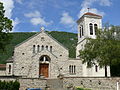
church
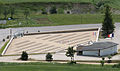
National Cemetery

La Mure Mill

