Saint-Nazaire-en-Royans
| Saint-Nazaire-en-Royans | ||
|---|---|---|

|
|
|
| region | Auvergne-Rhône-Alpes | |
| Department | Drôme | |
| Arrondissement | The | |
| Canton | Vercors-Monts du Matin | |
| Community association | Royans-Vercors | |
| Coordinates | 45 ° 4 ′ N , 5 ° 15 ′ E | |
| height | 157-701 m | |
| surface | 3.54 km 2 | |
| Residents | 804 (January 1, 2017) | |
| Population density | 227 inhabitants / km 2 | |
| Post Code | 26190 | |
| INSEE code | 26320 | |
| Website | www.saint-nazaire-en-royans.com | |
 Town hall ( Mairie ) of Saint-Nazaire-en-Royans |
||
Saint-Nazaire-en-Royans is a French municipality with 804 inhabitants (at January 1, 2017) in the department of Drôme in the region Auvergne Rhône-Alpes (before 2016 Rhône-Alpes ). It belongs to the Arrondissement Die (until 2017 Valence ) of the canton Vercors-Monts du Matin (until 2015 Saint-Jean-en-Royans ). The inhabitants are called Nazairois .
geography
Saint-Nazaire-en-Royans is located about 30 kilometers northeast of Valence at the confluence of the Bourne and Isère . The municipality belongs to the Vercors Regional Nature Park . Saint-Nazaire-en-Royans is surrounded by the neighboring communities of Saint-Hilaire-du-Rosier in the north, Saint-Just-de-Claix in the north and east, La Motte-Fanjas in the east and south-east, Rochechinard in the south and La Baume- d'Hostun to the west.
Population development
| year | 1911 | 1962 | 1968 | 1975 | 1982 | 1990 | 1999 | 2006 | 2013 |
|---|---|---|---|---|---|---|---|---|---|
| Residents | 696 | 648 | 590 | 493 | 576 | 531 | 498 | 677 | 795 |
Attractions
- Romanesque church
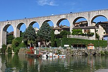
- Aqueduct from 1876
- Rochebrune tower from the 11th / 12th centuries century
- Thais cave

