
Aouste-sur-Sye
| Aouste-sur-Sye | ||
|---|---|---|
.svg)
|
|
|
| region | Auvergne-Rhône-Alpes | |
| Department | Drôme | |
| Arrondissement | The | |
| Canton | Crest | |
| Community association | Crestois and Pays de Saillans | |
| Coordinates | 44 ° 43 ' N , 5 ° 3' E | |
| height | 186-841 m | |
| surface | 17.98 km 2 | |
| Residents | 2,524 (January 1, 2017) | |
| Population density | 140 inhabitants / km 2 | |
| Post Code | 26400 | |
| INSEE code | 26011 | |
| Website | www.mairie-aouste-sur-sye.fr | |
 Historic wall on the Drôme river |
||

Aouste-sur-Sye is a French commune with 2524 inhabitants (as of January 1, 2017) in the Drôme department of the Auvergne-Rhône-Alpes region .
geography
The village of Aouste-sur-Sye lies west of the Vercors at the confluence of the Sye and the Drôme , a right tributary of the Rhone .

Roman wall

Village views
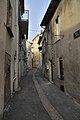
Rue de l'hôpital.


Web links
Commons : Aouste-sur-Sye - collection of images, videos and audio files