
Le Poët-Célard
| Le Poët-Célard | ||
|---|---|---|
|
||
| region | Auvergne-Rhône-Alpes | |
| Department | Drôme | |
| Arrondissement | The | |
| Canton | Dieulefit | |
| Community association | Val de Drôme | |
| Coordinates | 44 ° 36 ' N , 5 ° 6' E | |
| height | 351-744 m | |
| surface | 8.34 km 2 | |
| Residents | 127 (January 1, 2017) | |
| Population density | 15 inhabitants / km 2 | |
| Post Code | 26460 | |
| INSEE code | 26241 | |
 Mairie Le Poët-Célard |
||

Le Poët-Célard is a French municipality with 127 inhabitants (at January 1, 2017) in the department of Drôme in the region Auvergne Rhône-Alpes .
geography
Le Poët-Célard is located in the Arrondissement of Die and in the canton of Dieulefit , in the center of the Drôme department. The municipality lies between 351 and 744 m and is located about three kilometers northwest of Bourdeaux and 28 km east of Montélimar (as the crow flies). The village settlement lies in a small valley depression and is partially enclosed by forest.
Villagescape
The old village center lies on a small hill, at 543 m, and consists of typical southern French stone houses and the Saint-André castle with its well-preserved curtain walls; this was built in the late Middle Ages. The Roman Catholic Church rounds off the intact village image.
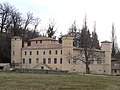
Saint-André castle

Former Sainte-Foy church, now the parish hall

Fallen memorial


Population development
| year | 1962 | 1968 | 1975 | 1982 | 1990 | 1999 | 2006 | 2016 |
| Residents | 176 | 162 | 150 | 137 | 142 | 145 | 128 | 126 |
Le Poët-Célard is one of the smaller communities in the Drôme department with 127 inhabitants (as of January 1, 2017).