Saint-Thomas-en-Royans
| Saint-Thomas-en-Royans | ||
|---|---|---|
|
|
||
| region | Auvergne-Rhône-Alpes | |
| Department | Drôme | |
| Arrondissement | The | |
| Canton | Vercors-Monts du Matin | |
| Community association | Royans-Vercors | |
| Coordinates | 45 ° 3 ' N , 5 ° 18' E | |
| height | 164-390 m | |
| surface | 5.15 km 2 | |
| Residents | 596 (January 1, 2017) | |
| Population density | 116 inhabitants / km 2 | |
| Post Code | 26190 | |
| INSEE code | 26331 | |
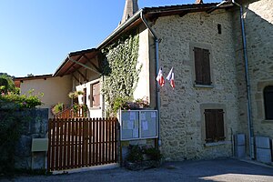
 Town hall ( Mairie ) of Saint-Thomas-en-Royans |
||
Saint-Thomas-en-Royans is a French municipality with 596 inhabitants (at January 1, 2017) in the department of Drôme in the region Auvergne Rhône-Alpes (before 2016 Rhône-Alpes ). It belongs to the Arrondissement Die (until 2017 Valence ) of the canton Vercors-Monts du Matin (until 2015 Saint-Jean-en-Royans ).
geography
Saint-Thomas-en-Royans is located about 35 kilometers northeast of Valence on the Bourne , which borders the municipality in the north. The municipality belongs to the Vercors Regional Nature Park . Saint-Thomas-en-Royans is surrounded by the neighboring communities of Saint-Just-de-Claix in the north, Auberives-en-Royans in the north and northeast, Saint-Laurent-en-Royans in the east and southeast, Saint-Jean-en- Royans in the south and La Motte-Fanjas in the west.
Population development
| year | 1911 | 1962 | 1968 | 1975 | 1982 | 1990 | 1999 | 2006 | 2013 |
|---|---|---|---|---|---|---|---|---|---|
| Residents | 305 | 186 | 216 | 230 | 328 | 440 | 476 | 502 | 576 |
Attractions
- Saint-Thomas church from the 12th century
- Gallo-Roman grave
- Castle of La Chartronnière
