
Luc-en-Diois
| Luc-en-Diois | ||
|---|---|---|
|
||
| region | Auvergne-Rhône-Alpes | |
| Department | Drôme | |
| Arrondissement | The | |
| Canton | Le Diois | |
| Community association | Diois | |
| Coordinates | 44 ° 40 ′ N , 5 ° 27 ′ E | |
| height | 501-1,245 m | |
| surface | 23.49 km 2 | |
| Residents | 527 (January 1, 2017) | |
| Population density | 22 inhabitants / km 2 | |
| Post Code | 26310 | |
| INSEE code | 26167 | |
| Website | http://www.luc-en-diois.fr/ | |
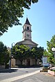
 Town hall (Mairie) by Luc-en-Diois |
||

Luc-en-Diois is a French municipality with 527 inhabitants (as of January 1 2017) in the department of Drôme in the region Auvergne Rhône-Alpes (before 2016 Rhône-Alpes ). It belongs to the Arrondissement Die , the canton Le Diois (until 2015: Canton Luc-en-Diois ) and the local authority association Diois, founded in 2001 .
geography
Luc-en-Diois is about 55 kilometers southeast of Valence . Neighboring municipalities of Luc-en-Diois are Menglon in the north and northeast, Miscon in the east and northeast, Lesches-en-Diois in the east and southeast, Beaumont-en-Diois in the south, Poyols in the west and southwest, Montlaur-en-Diois in the West and north-west and Recoubeau-Jansac in the west.
The commune is located in the Châtillon-en-Diois wine-growing region and on the former Route nationale 93 (today's D93).
history
Remains of a Roman city, which probably existed since the first century BC, can be found in the ground around today's location.
Population development
| year | 1962 | 1968 | 1975 | 1982 | 1990 | 1999 | 2006 | 2016 |
|---|---|---|---|---|---|---|---|---|
| Residents | 545 | 518 | 452 | 450 | 478 | 490 | 526 | 489 |
Sources: Cassini and INSEE
Attractions
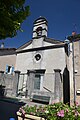
- Church of the Blessed Virgin ( Église de la Sainte-Vierge )
- Protestant Church
- The statue menhir of Die is exhibited in the Archaeological Museum of Die and Luc-en-Diois (Musée de Die et du Diois).
Church of the Holy Virgin
Protestant Church

