
Establet
| Establet | ||
|---|---|---|
|
||
| region | Auvergne-Rhône-Alpes | |
| Department | Drôme | |
| Arrondissement | The | |
| Canton | Le Diois | |
| Community association | Diois | |
| Coordinates | 44 ° 30 ′ N , 5 ° 26 ′ E | |
| height | 632-1,400 m | |
| surface | 12.58 km 2 | |
| Residents | 27 (January 1, 2017) | |
| Population density | 2 inhabitants / km 2 | |
| Post Code | 26470 | |
| INSEE code | 26123 | |

Establet is a French municipality with 27 inhabitants (at January 1, 2017) in the south of the department Drôme in the region Auvergne Rhône-Alpes . It belongs to the canton of Le Diois and the municipal association Pays Diois .
geography
Establet is about 30 kilometers northeast of Nyons .
Population development
| year | 1962 | 1968 | 1975 | 1982 | 1990 | 1999 | 2006 | 2016 |
| Residents | 49 | 33 | 25th | 14th | 19th | 21st | 26th | 28 |
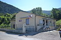
Mairie Establet

Protestant Church


Web links
Commons : Establet - collection of images, videos and audio files