
Plan-de-Baix
|
Plan de Baix Lo Plan de Bais |
||
|---|---|---|
|
||
| region | Auvergne-Rhône-Alpes | |
| Department | Drôme | |
| Arrondissement | The | |
| Canton | Crest | |
| Community association | Val de Drôme | |
| Coordinates | 44 ° 49 ′ N , 5 ° 10 ′ E | |
| height | 349–1,093 m | |
| surface | 19.39 km 2 | |
| Residents | 147 (January 1, 2017) | |
| Population density | 8 inhabitants / km 2 | |
| Post Code | 26400 | |
| INSEE code | 26240 | |
 Town hall (Mairie) of Plan-de-Baix |
||

Plan-de-Baix ( Occitan : Lo Plan de Bais ) is a French municipality with 147 inhabitants (as of January 1 2017) in the department of Drôme in the region Auvergne Rhône-Alpes ; it belongs to the arrondissement of Die and the canton of Crest (until 2015: canton of Crest-Nord ).
geography
Plan-de-Baix is about 25 kilometers southeast of Valence . Plan-de-Baix is surrounded by the neighboring communities of Le Chaffal in the north, Omblèze in the east and northeast, Eygluy-Escoulin in the southeast, Beaufort-sur-Gervanne in the south and Gigors-et-Lozeron in the west and southwest.
Population development
| year | 1962 | 1968 | 1975 | 1982 | 1990 | 1999 | 2006 | 2016 |
|---|---|---|---|---|---|---|---|---|
| Residents | 123 | 142 | 125 | 139 | 123 | 134 | 143 | 145 |
Attractions
- Montrond Castle
- Le Vellan rock
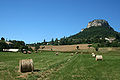
Le Vellan rock
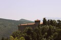
Montrond Castle


Web links
Commons : Plan-de-Baix - collection of images, videos and audio files