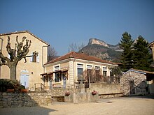
Vercheny
| Vercheny | ||
|---|---|---|
|
|
||
| region | Auvergne-Rhône-Alpes | |
| Department | Drôme | |
| Arrondissement | The | |
| Canton | Le Diois | |
| Community association | Crestois and Pays de Saillans | |
| Coordinates | 44 ° 43 ' N , 5 ° 15' E | |
| height | 280-1,109 m | |
| surface | 11.19 km 2 | |
| Residents | 461 (January 1, 2017) | |
| Population density | 41 inhabitants / km 2 | |
| Post Code | 26340 | |
| INSEE code | 26368 | |
Vercheny is a French commune in the Drôme department in the region of Auvergne Rhône-Alpes . It belongs to the canton of Le Diois and the arrondissement of Die . It borders on Véronne to the north-west, Pontaix to the north, Barsac to the north-east, Aurel to the south-east and Espenel to the south and south-west . The municipality is affected by the former Route nationale 93 .
Population development
| year | 1962 | 1968 | 1975 | 1982 | 1990 | 1999 | 2008 | 2016 |
|---|---|---|---|---|---|---|---|---|
| Residents | 253 | 268 | 415 | 421 | 427 | 387 | 437 | 450 |
Attractions
- Pont d'Aurel , a bridge over the Drôme between Vercheny and Aurel from 1193
economy
In Vercheny, parts of the vineyards are approved for the production of the sparkling wines Clairette de Die and Crémant de Die and the white wine Coteaux-de-die .
Web links
Commons : Vercheny - collection of images, videos and audio files

