
Choranche
| Choranche | ||
|---|---|---|
|
||
| region | Auvergne-Rhône-Alpes | |
| Department | Isère | |
| Arrondissement | Grenoble | |
| Canton | Le Sud Grésivaudan | |
| Community association | Saint-Marcellin Vercors Isère Communauté | |
| Coordinates | 45 ° 4 ' N , 5 ° 24' E | |
| height | 200-1,200 m | |
| surface | 10.63 km 2 | |
| Residents | 121 (January 1, 2017) | |
| Population density | 11 inhabitants / km 2 | |
| Post Code | 38680 | |
| INSEE code | 38108 | |
| Website | http://choranche.sud-gresivaudan.org/ | |
 Town Hall (Mairie) of Choranche |
||

Choranche is a French municipality with 121 inhabitants (as of January 1 2017) in the department of Isère in the region Auvergne Rhône-Alpes (before 2016 Rhône-Alpes ). It belongs to the Arrondissement of Grenoble and the canton of Le Sud Grésivaudan (until 2015 Pont-en-Royans ).
geography
Choranche is located about 33 kilometers west-southwest of Grenoble on the Bourne , which borders the municipality in the south, in the historic Dauphiné landscape . Choranche is surrounded by the neighboring parishes of Presles in the north, Rencurel in the north-east, Saint-Julien-en-Vercors in the east and south-east, Châtelus in the south, Pont-en-Royans in the west and Saint-André-en-Royans in the north-west.
Population development
| year | 1962 | 1968 | 1975 | 1982 | 1990 | 1999 | 2006 | 2013 |
| Residents | 151 | 149 | 115 | 130 | 132 | 130 | 134 | 128 |
| Source: Cassini and INSEE | ||||||||
Attractions
- church
- Choranche caves

church
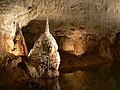
Choranche cave system


Web links
Commons : Choranche - collection of images, videos and audio files