Chapareillan
| Chapareillan | ||
|---|---|---|

|
|
|
| region | Auvergne-Rhône-Alpes | |
| Department | Isère | |
| Arrondissement | Grenoble | |
| Canton | Haut-Grésivaudan | |
| Community association | Le Grésivaudan | |
| Coordinates | 45 ° 28 ′ N , 6 ° 0 ′ E | |
| height | 245-1,934 m | |
| surface | 30 km 2 | |
| Residents | 3,010 (January 1, 2017) | |
| Population density | 100 inhabitants / km 2 | |
| Post Code | 38530 | |
| INSEE code | 38075 | |
| Website | www.chapareillan.fr | |
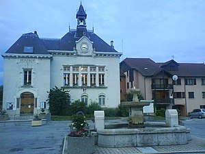
 Chapareillan Town Hall |
||
Chapareillan is a French commune with 3,010 inhabitants (as of January 1 2017) in the department of Isère in the region Auvergne Rhône-Alpes ; it belongs to the Arrondissement of Grenoble and the canton of Haut-Grésivaudan . The inhabitants are called Chapareillannais .
geography
Chapareillan is located west of the Isère in the Grésivaudan landscape and also in the Savoie wine-growing region . Chapareillan is surrounded by the neighboring communities of Porte-de-Savoie with Les Marches in the north and northeast, Laissaud in the east, Pontcharra in the southeast, Barraux in the south and southeast, Sainte-Marie-du-Mont in the south and southwest, and Entremont-le-Vieux in the West.
The municipality is crossed by the Autoroute A41 and the former Route nationale 90 (today's D1090).
Population development
| year | 1962 | 1968 | 1975 | 1982 | 1990 | 1999 | 2006 | 2017 |
|---|---|---|---|---|---|---|---|---|
| Residents | 1300 | 1302 | 1418 | 1682 | 1898 | 2147 | 2477 | 3010 |
Attractions
- Old church
- Bellecombe Church
- Ruins of Bellecombe Castle
- Hauterive Castle
- Pizançon Castle
- Medieval town center

