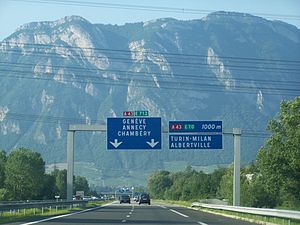
Autoroute A 41
| Autoroute A41 in France | ||||||||||||||||||||||||||||||||||||||||||||||||||||||||||||||||

|
||||||||||||||||||||||||||||||||||||||||||||||||||||||||||||||||
| map | ||||||||||||||||||||||||||||||||||||||||||||||||||||||||||||||||
| Basic data | ||||||||||||||||||||||||||||||||||||||||||||||||||||||||||||||||
| Operator: | ADELAC | |||||||||||||||||||||||||||||||||||||||||||||||||||||||||||||||
| further operator: | AREA, ATMB | |||||||||||||||||||||||||||||||||||||||||||||||||||||||||||||||
| Overall length: | 112 km | |||||||||||||||||||||||||||||||||||||||||||||||||||||||||||||||
|
Regions : |
||||||||||||||||||||||||||||||||||||||||||||||||||||||||||||||||
| Transition from the A 41 to the A 43 | ||||||||||||||||||||||||||||||||||||||||||||||||||||||||||||||||
|
Course of the road
|
||||||||||||||||||||||||||||||||||||||||||||||||||||||||||||||||
The French Autoroute A 41 , also known as L'Alpine , is a four-lane (2 × 2 lanes) motorway that connects the Grenoble region to the A 40 at Saint-Julien-en-Genevois . It is divided into two parts ( north and south ) connected by the N 201 . The southern part merges directly into the N 201, the northern part is connected to the N 201 via the Chambéry-Nord exit. There the A 41 merges in a straight line with the A 43 . It has a total length of 112 km.
Routing
The A 41 crosses three departments and connects the following regions to the national road network:
Isère
Savoie
Haute-Savoie
Web links
- Autoroute A 41 in German and French version of the SARATLAS
- Autoroute A 41 on WikiSara (French)


