Autoroute A 4
| Autoroute A4 in France | |||||||||||||||||||||||||||||||||||||||||||||||||||||||||||||||||||||||||||||||||||||||||||||||||||||||||||||||||||||||||||||||||||||||||||||||||||||||||||||||||||||||||||||||||||||||||||||||||||||||||||||||||||||||||||||||||||||||||||||||||||||||||||||||||||||||||||||||||||||||||||||||||||||||||||||||||||||||||

|
|||||||||||||||||||||||||||||||||||||||||||||||||||||||||||||||||||||||||||||||||||||||||||||||||||||||||||||||||||||||||||||||||||||||||||||||||||||||||||||||||||||||||||||||||||||||||||||||||||||||||||||||||||||||||||||||||||||||||||||||||||||||||||||||||||||||||||||||||||||||||||||||||||||||||||||||||||||||||
| |
|||||||||||||||||||||||||||||||||||||||||||||||||||||||||||||||||||||||||||||||||||||||||||||||||||||||||||||||||||||||||||||||||||||||||||||||||||||||||||||||||||||||||||||||||||||||||||||||||||||||||||||||||||||||||||||||||||||||||||||||||||||||||||||||||||||||||||||||||||||||||||||||||||||||||||||||||||||||||
| map | |||||||||||||||||||||||||||||||||||||||||||||||||||||||||||||||||||||||||||||||||||||||||||||||||||||||||||||||||||||||||||||||||||||||||||||||||||||||||||||||||||||||||||||||||||||||||||||||||||||||||||||||||||||||||||||||||||||||||||||||||||||||||||||||||||||||||||||||||||||||||||||||||||||||||||||||||||||||||
| Basic data | |||||||||||||||||||||||||||||||||||||||||||||||||||||||||||||||||||||||||||||||||||||||||||||||||||||||||||||||||||||||||||||||||||||||||||||||||||||||||||||||||||||||||||||||||||||||||||||||||||||||||||||||||||||||||||||||||||||||||||||||||||||||||||||||||||||||||||||||||||||||||||||||||||||||||||||||||||||||||
| Operator: | SANEF | ||||||||||||||||||||||||||||||||||||||||||||||||||||||||||||||||||||||||||||||||||||||||||||||||||||||||||||||||||||||||||||||||||||||||||||||||||||||||||||||||||||||||||||||||||||||||||||||||||||||||||||||||||||||||||||||||||||||||||||||||||||||||||||||||||||||||||||||||||||||||||||||||||||||||||||||||||||||||
| Overall length: | 482 km | ||||||||||||||||||||||||||||||||||||||||||||||||||||||||||||||||||||||||||||||||||||||||||||||||||||||||||||||||||||||||||||||||||||||||||||||||||||||||||||||||||||||||||||||||||||||||||||||||||||||||||||||||||||||||||||||||||||||||||||||||||||||||||||||||||||||||||||||||||||||||||||||||||||||||||||||||||||||||
|
Regions : |
|||||||||||||||||||||||||||||||||||||||||||||||||||||||||||||||||||||||||||||||||||||||||||||||||||||||||||||||||||||||||||||||||||||||||||||||||||||||||||||||||||||||||||||||||||||||||||||||||||||||||||||||||||||||||||||||||||||||||||||||||||||||||||||||||||||||||||||||||||||||||||||||||||||||||||||||||||||||||
| The A4 near Paris. | |||||||||||||||||||||||||||||||||||||||||||||||||||||||||||||||||||||||||||||||||||||||||||||||||||||||||||||||||||||||||||||||||||||||||||||||||||||||||||||||||||||||||||||||||||||||||||||||||||||||||||||||||||||||||||||||||||||||||||||||||||||||||||||||||||||||||||||||||||||||||||||||||||||||||||||||||||||||||
|
Course of the road
|
|||||||||||||||||||||||||||||||||||||||||||||||||||||||||||||||||||||||||||||||||||||||||||||||||||||||||||||||||||||||||||||||||||||||||||||||||||||||||||||||||||||||||||||||||||||||||||||||||||||||||||||||||||||||||||||||||||||||||||||||||||||||||||||||||||||||||||||||||||||||||||||||||||||||||||||||||||||||||
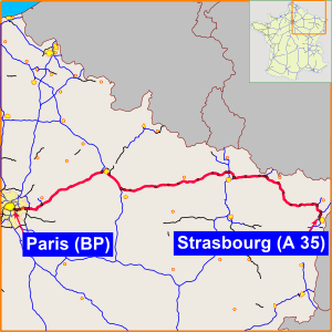
The A 4 Autoroute , also known as the Autoroute de l'Est or Ostautobahn, is the second longest French motorway after the A 10 with a total of 482 km . It runs from Paris via Reims and Metz to Strasbourg to the Franco-German border and is part of two European roads.
From Paris to Freyming-Merlebach it is identical to the E 50 , which merges into the German A 6 via the 15 km long A 320 at the Goldene Bremm border crossing near Saarbrücken , and from Metz to Strasbourg it is identical to the E 25 .
It is managed by SANEF and is largely subject to tolls . Coming from Paris (BP) to the Marne-la-Vallée / Val d'Europe exit and from Strasbourg to the motorway triangle where the A 340 branches off to Haguenau, the motorway is toll-free.
history
The route between Metz and Merlebach was completed in 1971 as the A32. The section between Strasbourg and Mundolsheim was opened as the A 34 in 1972 and extended to Merlebach in 1976. In 1982, both motorways were integrated into the A4, which was built between Paris and Metz between 1970 and 1976. On November 23, 2010, the new southern bypass of Reims was opened, to which the A4 was relocated. Since then, part of the old city passage has been part of the A 34 or was renamed the A 344.
Trivia
An installation made of multi-colored concrete elements in simple geometric shapes is attached to the embankments on both sides of the motorway between route kilometers 181 and 209. This was designed in 1974 by the French painter and sculptor Guy de Rougemont , member of the Académie des Beaux-Arts , on behalf of the operating company. It is intended to improve the concentration of the drivers on the otherwise very monotonous route between Verdun and Châlons-en-Champagne (then Châlons-sur-Marne).
See also
Web links
swell
- ↑ Information from the operating company SANEF by email in August 2015


