Autoroute A 26
| Autoroute A26 in France | |||||||||||||||||||||||||||||||||||||||||||||||||||||||||||||||||||||||||||||||||||||||||||||||||||||||||||||||||||||||||||||||||||||||||||||||||||||||||||||||||||||||||

|
|||||||||||||||||||||||||||||||||||||||||||||||||||||||||||||||||||||||||||||||||||||||||||||||||||||||||||||||||||||||||||||||||||||||||||||||||||||||||||||||||||||||||
| |
|||||||||||||||||||||||||||||||||||||||||||||||||||||||||||||||||||||||||||||||||||||||||||||||||||||||||||||||||||||||||||||||||||||||||||||||||||||||||||||||||||||||||
| map | |||||||||||||||||||||||||||||||||||||||||||||||||||||||||||||||||||||||||||||||||||||||||||||||||||||||||||||||||||||||||||||||||||||||||||||||||||||||||||||||||||||||||
| Basic data | |||||||||||||||||||||||||||||||||||||||||||||||||||||||||||||||||||||||||||||||||||||||||||||||||||||||||||||||||||||||||||||||||||||||||||||||||||||||||||||||||||||||||
| Operator: | SANEF | ||||||||||||||||||||||||||||||||||||||||||||||||||||||||||||||||||||||||||||||||||||||||||||||||||||||||||||||||||||||||||||||||||||||||||||||||||||||||||||||||||||||||
| Overall length: | 361 km | ||||||||||||||||||||||||||||||||||||||||||||||||||||||||||||||||||||||||||||||||||||||||||||||||||||||||||||||||||||||||||||||||||||||||||||||||||||||||||||||||||||||||
|
Regions : |
|||||||||||||||||||||||||||||||||||||||||||||||||||||||||||||||||||||||||||||||||||||||||||||||||||||||||||||||||||||||||||||||||||||||||||||||||||||||||||||||||||||||||
| The A 26 at the cross with the A 2 | |||||||||||||||||||||||||||||||||||||||||||||||||||||||||||||||||||||||||||||||||||||||||||||||||||||||||||||||||||||||||||||||||||||||||||||||||||||||||||||||||||||||||
|
Course of the road
|
|||||||||||||||||||||||||||||||||||||||||||||||||||||||||||||||||||||||||||||||||||||||||||||||||||||||||||||||||||||||||||||||||||||||||||||||||||||||||||||||||||||||||
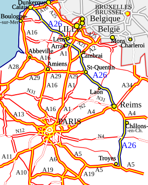
The French Autoroute A 26 is a 361 km long motorway in northern France that connects Calais and Troyes . It is also called the Autoroute des Anglais because it forms the main connection between the Dover- Calais ferry route or the Eurotunnel and the north and east of France. A large number of British vehicles use this motorway, particularly during the summer holiday season. Before the opening of the A 16 in the 1990s, the A 26 was part of the road link from London to Paris .
The motorway is part of the European roads E 15 and E 17 .
route
The motorway begins in Calais at the junction with the A 16 , from here there is also direct access to the car ferries. The motorway then runs south-east past the towns of Saint-Omer , Béthune , Lens and Arras . Near Arras crosses A 1 , which leads to Paris.
The A 26 continues in a south-easterly direction, past Cambrai , Saint-Quentin and Laon , before joining the A 4 near Reims . For the next 36 km, the A 26 and A 4 run together to Châlons-en-Champagne , where the motorways separate again. The A 26 continues south until it meets the A 5 at the motorway junction near Troyes .
The motorway is operated by SANEF .
future
The A 26 is to be extended to the A 71 near Bourges via Auxerre by 2025. It will replace the N 77 and N 151 , which, like the A 26, are part of the second variant of the Grand contournement de Paris .
Web links
- Autoroute A 26 in German and French version of the SARATLAS
- Autoroute A 26 on WikiSara (French)


