Autoroute A 2
| Autoroute A2 in France | ||||||||||||||||||||||||||||||||||||||||||||||||||||||||||||||||||||||||||||||||||

|
||||||||||||||||||||||||||||||||||||||||||||||||||||||||||||||||||||||||||||||||||
| |
||||||||||||||||||||||||||||||||||||||||||||||||||||||||||||||||||||||||||||||||||
| map | ||||||||||||||||||||||||||||||||||||||||||||||||||||||||||||||||||||||||||||||||||
| Basic data | ||||||||||||||||||||||||||||||||||||||||||||||||||||||||||||||||||||||||||||||||||
| Operator: |
SANEF Hauts-de-France |
|||||||||||||||||||||||||||||||||||||||||||||||||||||||||||||||||||||||||||||||||
| Start of the street: |
Combles ( 50 ° 2 ′ N , 2 ° 53 ′ E ) |
|||||||||||||||||||||||||||||||||||||||||||||||||||||||||||||||||||||||||||||||||
| End of street: |
Saint-Aybert ( 50 ° 26 ′ N , 3 ° 40 ′ E ) |
|||||||||||||||||||||||||||||||||||||||||||||||||||||||||||||||||||||||||||||||||
| Overall length: | 76 km | |||||||||||||||||||||||||||||||||||||||||||||||||||||||||||||||||||||||||||||||||
|
Regions : |
||||||||||||||||||||||||||||||||||||||||||||||||||||||||||||||||||||||||||||||||||
| Development condition: | 2 × 2 lanes | |||||||||||||||||||||||||||||||||||||||||||||||||||||||||||||||||||||||||||||||||
| A2 1000 m from the Franco-Belgian border | ||||||||||||||||||||||||||||||||||||||||||||||||||||||||||||||||||||||||||||||||||
|
Course of the road
|
||||||||||||||||||||||||||||||||||||||||||||||||||||||||||||||||||||||||||||||||||
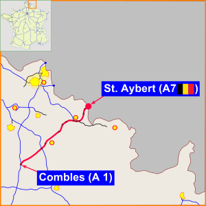
The Autoroute A 2 ( French for 'Autobahn A 2') is a French motorway that connects the A 1 motorway with the Belgian motorway 7 over a total length of 76 kilometers . It starts near the municipality of Combles in the Somme department and ends at the Belgian border. Its entire length is part of Europastraße 19 .
The motorway is operated as a toll motorway in the area between Combles and Hordain by the motorway operator SANEF and then from the Hauts-de-France to the Belgian border.
See also
Web links
- Autoroute A2 in German and French version of the SARATLAS
- Autoroute A2 on WikiSara (French)


