Saint-Aybert
| Saint-Aybert | ||
|---|---|---|
|
|
||
| region | Hauts-de-France | |
| Department | North | |
| Arrondissement | Valenciennes | |
| Canton | Marly | |
| Community association | Valenciennes Métropole | |
| Coordinates | 50 ° 27 ' N , 3 ° 39' E | |
| height | 15-20 m | |
| surface | 4.19 km 2 | |
| Residents | 379 (January 1, 2017) | |
| Population density | 90 inhabitants / km 2 | |
| Post Code | 59163 | |
| INSEE code | 59530 | |
 Town hall (Mairie) of Saint-Aybert |
||
Saint-Aybert is a French municipality with 379 inhabitants (as of January 1 2017) in the department of Nord in the region of Hauts-de-France . Escautpont belongs to the arrondissement of Valenciennes and the canton of Marly (until 2015: canton of Condé-sur-l'Escaut ).
geography
Saint-Aybert is about twelve kilometers northwest of Valenciennes am Haine and on the border with Belgium . Saint-Aybert is surrounded by the neighboring communities of Harchies (Belgium) in the north, Hensies (Belgium) in the east, Crespin in the south, Thivencelle in the west and Condé-sur-l'Escaut in the west and northwest.
In the southeast of the municipality, the border crossing with the former clearance point is on Autoroute A2 .
Population development
| year | 1962 | 1968 | 1975 | 1982 | 1990 | 1999 | 2006 | 2013 |
|---|---|---|---|---|---|---|---|---|
| Residents | 344 | 319 | 275 | 296 | 295 | 339 | 361 | 358 |
Attractions
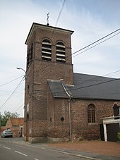
- Saint-Aybert church from the 19th century
- Saint Roch chapel
- At the former border crossing there is a monumental work of art by Jacques Moeschal
literature
- Le Patrimoine des Communes du Nord. Flohic Editions, Volume 1, Paris 2001, ISBN 2-84234-119-8 , pp. 579-580.
Web links
Commons : Saint-Aybert - Collection of images, videos and audio files
Individual evidence
- ↑ Saint-Aybert on the Insee website

