
Trith-Saint-Léger
| Trith-Saint-Léger | ||
|---|---|---|

|
|
|
| region | Hauts-de-France | |
| Department | North | |
| Arrondissement | Valenciennes | |
| Canton | Aulnoy-lez-Valenciennes | |
| Community association | Porte du Hainaut | |
| Coordinates | 50 ° 20 ′ N , 3 ° 29 ′ E | |
| height | 21-81 m | |
| surface | 6.87 km 2 | |
| Residents | 6,215 (January 1, 2017) | |
| Population density | 905 inhabitants / km 2 | |
| Post Code | 59125 | |
| INSEE code | 59603 | |
| Website | http://www.trith.fr/ | |
 Trith-Saint-Léger town hall |
||

Trith-Saint-Léger (NDL .: "Tricht") is a French municipality with 6215 inhabitants (as of January 1 2017) in the department of Nord in the region of Hauts-de-France . It belongs to the municipal association La Porte du Hainaut , the arrondissement Valenciennes and is part of the canton Aulnoy-lez-Valenciennes . The inhabitants are called Trithois (es) .
geography
Trith-Saint-Léger is located in northern France. Here the Écaillon flows into the Scheldt (French Escaut). Trith-Saint-Léger is surrounded by the neighboring municipalities of La Sentinelle and Valenciennes in the north, Aulnoy-lez-Valenciennes in the east, Famars in the southeast, Maing in the south and Prouvy in the west.
Autoroute A2 runs along the northern edge of the municipality .
history
Trith was mentioned in the books of the Counts of Valenciennes in the 11th century .
| year | 1962 | 1968 | 1975 | 1982 | 1990 | 1999 | 2006 | 2012 |
| Residents | 7,098 | 7.612 | 6,757 | 5952 | 6,208 | 6,196 | 6.367 | 6,393 |
Attractions
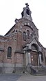
- Saint Martin Church
- Saint-Éloi church
- Trith-Saint-Léger station from 1885

Saint Martin Church
Saint-Éloi church
_%C3%A9glise_Saint-Martin.JPG)
.JPG)
Personalities
- Frédéric Wallerant (1858–1936), mineralogist and crystallographer
- Aimable Pluchard (1922-1997), accordionist
- Daniel Leclercq (born 1949), football player
literature
- Le Patrimoine des Communes du Nord. Flohic Editions, Volume 2, Paris 2001, ISBN 2-84234-119-8 , pp. 1684-1685.
Web links
- Monuments historiques (objects) in Trith-Saint-Léger in the base Palissy of the French Ministry of Culture
Individual evidence
- ^ De Nederlanden in Frankrijk, Jozef van Overstraeten, 1969