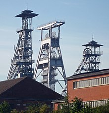
Wallers
| Wallers | ||
|---|---|---|

|
|
|
| region | Hauts-de-France | |
| Department | North | |
| Arrondissement | Valenciennes | |
| Canton | Saint-Amand-les-Eaux | |
| Community association | Porte du Hainaut | |
| Coordinates | 50 ° 23 ' N , 3 ° 24' E | |
| height | 15-135 m | |
| surface | 20.89 km 2 | |
| Residents | 5,526 (January 1, 2017) | |
| Population density | 265 inhabitants / km 2 | |
| Post Code | 59135 | |
| INSEE code | 59632 | |
| Website | www.ville-de-wallers-arenberg.fr | |
Wallers (NDL .: Wallaar) is a French municipality with 5526 inhabitants (at January 1, 2017) in Nord in the region of Hauts-de-France . With its Wallers-Arenberg mine , the community is of industrial historical importance. Thanks to the Trouée d'Arenberg , an important passage in the Paris – Roubaix cycle race , Wallers also has a tourist significance that goes beyond industrial culture.
history
The area around Wallers was already populated by humans over 45,000 years ago. This is indicated by human traces in the form of flint tools. Wallers was probably founded by the Merovingians . Wallers experienced its heyday in the 19th and 20th centuries. During this time two mines as well as sugar factories , breweries , brickworks , an enamel factory and a distillery were built . At the same time, the population increased from 1852 in 1801 to 7659 in 1954.
Architectural monuments
See: List of Monuments historiques in Wallers
literature
- Le Patrimoine des Communes du Nord. Flohic Editions, Volume 2, Paris 2001, ISBN 2-84234-119-8 , pp. 1717-1719.
Web links
- Official website of the municipality of Wallers-Arenberg (French)
- Wallers-Arenberg mine industrial monument
Individual evidence
- ^ De Nederlanden in Frankrijk, Jozef van Overstraeten, 1969

