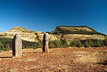
Cham des Bondons
On the Cham des Bondons plateau near Les Bondons in the Cevennes National Park in the Lozère department in southern France, there is a collection of 154 menhirs . This is the second largest concentration of menhirs in France after Carnac . Several stones have been recognized as monuments historiques since 1941 .
location
The approx. 1000 m above sea level. d. M. located limestone plateau des Cham des Bondons is only a few kilometers south or southwest of Mont Lozère within a radius of about 5 km around Les Bondons, in the northeast of Florac . The area is bounded to the south by the upper reaches of the Tarn . The high altitude and partially forested Cham des Bondons is not suitable for growing grain . There are several groups of menhirs here, including La Pierre des trois Paroisses near Saint-Étienne-du-Valdonnez and Caousou Viel near the hamlet of Veissière, the highest group at 1200 meters. 21 menhirs were erected again in 1982/83 with funds from the Ministère de l'Environnement by Gilbert Fages, the largest measuring 3.05 x 0.75 x 0.50 m.
Menhirs
The menhirs are made of the granite of Mont Lozère. The approximately 150 menhirs in the area are mostly single; however, there are also several small groups of two or three stones. The three menhirs de la Fage are exactly in a row approx. 120 m long. Most menhirs are only two to three meters high; some seem to have been smoothed on the surface, but this can also be due to typical forms in the weathering of the granite. All the stones were transported from the southern slopes of Mont Lozère over distances of at least 800 m and a maximum of around 3 km, with tree trunks being used as rollers and lever tools .
In contrast to many stones in the neighboring areas of the Rouergue or the entire Aveyron department, there are no incised drawings on the menhirs of the Cham des Bondons. They are - also because of their stele-like character - in the time around 3000 to 2500 BC. Dated, so much later than those in Brittany. One can only speculate about the background of so many menhirs on a relatively narrowly limited area - for example, it could have been cult or memorial sites of various family clans. In contrast to many other places in the Lozère department, however, there are only very few megalithic tombs ( dolmen ) on the Cham des Bondons, but several burial mounds ( tumuli ).
Settlements
In Caousou Viel, Fages found the remains of a Copper Age settlement.
Burials
The dolmen of La Fage (also Dolmen of Combes) is a small dolmen with a rectangular chamber, made of local limestone . They are in the center of a hill, all traces of the corridor and the cap stones have disappeared. It contained bone fragments, ceramics with a wavy edge, stone beads and triangular arrowheads . The discovery of an urn with a corpse burn proves that it was used in the late bronze age .
The Combes I burial mound was built in 1983 by J.-Y. Boutin unearthed. It contained a stone circle 6 m in diameter and a central cremation in an urn from the Late Bronze Age II.
Two more burial mounds are at Caousou Viel. Hill 1 contained no bones, which the excavator Gilbert Fages attributes to the acidic soil. No urn was found either. Two bronze bracelets resemble late Iron Age finds from the Champ Rond sur le Causse Méjean.
See also
Web links
- Menhirs des Cham des Bondons - photos + information (French)
- Cham des Bondons - map, photo + brief information (French)
- Dolmens and menhirs in the south of France - photos + information (French)
- Video
- Gilbert Fages: L'ensemble mégalithique des Bondons (French)
Individual evidence
- ↑ List of the monuments historiques de la Lozère in the French Wikipedia
- ^ A b c d Jean-Louis Roudil: Languedoc - Roussillon. In: Gallia préhistoire. Vol. 27, No. 2, 1984, ISSN 0016-4127 , pp. 349-373, here p. 371, ( digitized version ).
- ^ Fages Gilbert: Le site de Caousou Much, Les Bondons (Lozère). In: Bulletin de la Société Préhistorique Française. Vol. 85, No. 6, 1988, ISSN 0037-9514 , pp. 179-186, doi : 10.3406 / ex . 1988.9340 .
- ^ Jean-Yves Boutin: Le tumulus I des Combes, Les Bondons (Lozère). In: Bulletin de la Société Préhistorique Française. Vol. 87, No. 4, 1990, pp. 123-126, doi : 10.3406 / ex . 1990.9430 .
- ↑ Fages Gilbert: Quelques examples de signalisation et de réutilisation des sépultures protohistoriques des Causses lozériens. In: Documents d'Archéologie Méridionale. Vol. 17, 1994, ISSN 0184-1068 , pp. 13-19, here p. 15, doi : 10.3406 / dam.1994.1111 ; Dedet Bernard: Variabilité des pratiques funéraires protohistoriques dans le sud de la France: défunts incinérés, défunts non brûlés. In: Gallia. Vol. 61, 2004, ISSN 0016-4119 , pp. 193-222, here p. 203, doi : 10.3406 / galia.2004.3062 .
- ↑ Fages Gilbert: Quelques examples de signalisation et de réutilisation des sépultures protohistoriques des Causses lozériens. In: Documents d'Archéologie Méridionale. Vol. 17, 1994, pp. 13-19, here p. 15, doi : 10.3406 / dam.1994.1111
- ^ Fages Gilbert: Le site de Caousou Much, Les Bondons (Lozère). In: Bulletin de la Société Préhistorique Française. Vol. 85, No. 6, 1988, pp. 179-186, here p. 180, doi : 10.3406 / e.g. 1988.9340 .
- ^ Fages Gilbert: Le site de Caousou Much, Les Bondons (Lozère). In: Bulletin de la Société Préhistorique Française. Vol. 85, No. 6, 1988, pp. 179-186, here p. 182, doi : 10.3406 / ex . 1988.9340 .
- ^ Fages Gilbert: Le site de Caousou Much, Les Bondons (Lozère). In: Bulletin de la Société Préhistorique Française. Vol. 85, No. 6, 1988, pp. 179-186, here p. 183, doi : 10.3406 / ex . 1988.9340 .
Coordinates: 44 ° 24 ' N , 3 ° 36' E


