Tarn (river)
| Camouflage | ||
|
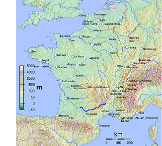
Location of the Tarn in France |
||
| Data | ||
| Water code | FR : O --- 0100 | |
| location | France , Occitania region | |
| River system | Garonne | |
| Drain over | Garonne → Atlantic Ocean | |
| source | in the municipality of Le Pont-de-Montvert 44 ° 24 ′ 54 ″ N , 3 ° 48 ′ 51 ″ E |
|
| Source height | approx. 1560 m | |
| muzzle | below Moissac in the Garonne Coordinates: 44 ° 5 '11 " N , 1 ° 2' 14" E 44 ° 5 '11 " N , 1 ° 2' 14" E |
|
| Mouth height | approx. 65 m | |
| Height difference | approx. 1495 m | |
| Bottom slope | approx. 3.9 ‰ | |
| length | 380 km | |
| Catchment area | 15,753 km² | |
| Outflow at the Moissac gauge |
MQ |
230 m³ / s |
| Medium-sized cities | Millau , Albi , Montauban | |
| Small towns | Saint-Juéry , Gaillac , Moissac | |
|
The Tarn in Albi |
||
The Tarn is a river in southern France that runs in the Occitania region .
course
The Tarn rises on the high plateau of Mont Lozère in the Cevennes , in the municipality of Le Pont-de-Montvert . In many changes of direction, the Tarn generally drains south-west to west, initially through the Cevennes National Park , later through the Grands Causses Regional Nature Park and flows into the Garonne as a right tributary after 380 kilometers below Moissac , in the dam area of the Malause weir system .
On its way, the Tarn crosses the Lozère , Aveyron , Haute-Garonne , Tarn and Tarn-et-Garonne departments . For the latter two, the river also serves as a namesake.
Places on the river
- Le Pont-de-Montvert
- Florac
- Ispagnac
- Rivière-sur-Tarn
- Millau
- Saint-Rome-de-Tarn
- Saint-Juéry
- Albi
- Marssac-sur-Tarn
- Gaillac
- Lisle-sur-Tarn
- Rabastens
- Saint-Sulpice-la-Pointe
- Mirepoix-sur-Tarn
- Villemur-sur-Tarn
- Labastide-Saint-Pierre
- Montauban
- Lafrançaise
- Moissac
Tributaries
|
Left tributaries: |
Right tributaries: |
Floods
Two high water marks on the sea wall of Albi on June 18, 1766 and March 3, 1930 herald the devastating floods of the Tarn.
shipping
Since the Tarn is not navigable for ships, some engineering structures were erected in order to still be able to manage the supply of the heavily populated estuary section via the water:
- The Canal de Montech branches off at Montauban and is supplied with water from the Tarn.
- In Moissac, the Tarn is crossed by the Canal latéral à la Garonne with the help of a trough bridge.
Attractions
- The Tarn is famous for its gorges ( Gorges du Tarn ), which have dug into the rock north of Millau and are now a tourist attraction.
- An architectural tourist attraction is the Viaduc de Millau , the tallest and longest cable-stayed bridge in the world, which leads over the Tarn near Millau.
- In addition to hikes, canoe tours are also popular with tourists and are organized by numerous canoe rentals.
Web links
Individual evidence
- ↑ a b geoportail.fr (1: 16,000)
- ↑ a b c The information on the length of the river is based on the information about the Tarn at SANDRE (French), accessed on April 17, 2011, rounded to full kilometers.
- ↑ hydro.eaufrance.fr (station: O5901010 , option: Synthèse )


