
Grands Causses Regional Nature Park

The Regional Nature Park Grands Causses ( French: Parc naturel régional des Grands Causses ) is located in the French department of Aveyron in the Occitania region .
The park extends roughly between the places
- Saint-Laurent-d'Olt in the north,
- Saint-Jean-du-Bruel in the east,
- Avène in the south (just outside the natural park),
- Saint-Sernin-sur-Rance in the south-west and
- Ségur in the northwest.
The city of Millau is in the center of the park. The nature park borders the Cevennes National Park to the east and the Haut-Languedoc Regional Nature Park to the south .
Park management

The nature park was founded on May 6, 1995 and today covers an area of around 327,000 hectares. The park administration is based in Millau ( 44 ° 5 '47 " N , 3 ° 4' 36" E ), where the "Maison du Parc" is located is located. 93 municipalities (as of January 1, 2016) with a catchment area of around 68,000 residents form the park.
Larger places in the park
- Millau
- Saint-Affrique
- Sévérac d'Aveyron (Commune nouvelle; formerly: Sévérac-le-Château )
- Creissels
- Vabres-l'Abbaye
- Saint-Georges-de-Luzençon
landscape
The park includes the following natural landscapes and biotopes :
- the Causses ( German: "Kalkplateaus")
- Causse de Sévérac (between the Lot and Aveyron rivers )
- Causse Noir (between the Jonte and Dourbie rivers )
- Causse du Larzac (southeast of Millau)
- the Avant-Causses (German: "Causse-Vorberge")
- the Rougiers (German: "Rotes Land") and
- the Monts (German: "Mountains").
Causses
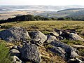
The limestone plateaus cover around 25% of the area of the nature park and some of them continue beyond its borders. They form large areas in the eastern part of the nature park, the height of which varies between 800 and 1100 meters. From a geological point of view, they consist of a base made of calcareous sediments that the sea deposited here around 200 million years ago. In the rock, which has become porous due to weathering , the precipitation seeps away immediately and forms a dry stony plateau, which is dominated by dry grass . This dry grassland landscape is particularly suitable for sheep breeding .
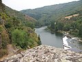
The rivers running through the area (such as Dourbie , Jonte , Tarn ) have dug up to 500 meters deep gorges ( French: Gorges) into the limestone and thus structured the landscape. The breaks are formed from steep walls jagged by caves.

Typical landscape at the Causse de Lazarc

Shepherd on the Causse de Larzac

Dolmen de Galitorte on the Causse de Sévérac

View of the Causse Noir

In the Tarn Gorges

La Truel in the Jonte gorges


Avant-Causses
The Avant-Causses , which are made up of smaller limestone plateaus and slightly hilly plains, extend at the foot of the large limestone plateaus (causses). Hedges and dry stone walls form a bocage landscape and in some places a so-called witness mountain appears in the landscape. They generally extend along the central axis of the nature park from north to south at an altitude of about 650 meters. From a geological point of view, the Avant-Causses are older than the great limestone plateaus (Causses). Many rivers ( Serre , Aveyron , Tarn , Dourbie , Cernon , Sorgue ) have dug valleys into the Avant-Causses . The prevailing fertile soil, which is irrigated by numerous springs, has attracted people since ancient times and has created agricultural areas where cattle and sheep are raised . On the hills, mostly fruit and viticulture are traditionally practiced on terraces . It is in these territories that the three largest cities in the park have developed: Millau , Saint-Affrique and Sévérac-le-Château .
Saint-Affrique on the Sorgue River

View from the castle in Sévérac-le-Château to the A75

Saint-Georges-de-Luzençon

Millau motorway viaduct
View of Millau
Saint-Rome-de-Tarn


Rougiers
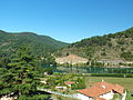
This landscape in the southwest of the nature park is known for the wine-red color of its rocks and earth , which is due to an intensive admixture of iron oxide . It consists essentially of sandstone and was formed around 250 to 300 million years ago. The Dourdou de Camarès and Rance rivers cross this territory. Its low altitude (250 to 550 meters), its warm and dry climate in summer and its abundance of water have enabled high-yielding agricultural crops. Through the establishment of our own irrigation systems at the end of the 19th century, the feed yields were further increased and this enabled intensive rearing of the milk sheep for the production of Roquefort cheese . Together with the Avant-Causses, the Rougiers are among the most populated zones in the area of the nature park. The main towns are Camarès , Montlaur , Vabres-l'Abbaye and Saint-Izaire .

The red earth near Camarès

The red earth near Montlaur

The red earth near Montlaur
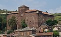
Castle of Saint-Izaire

Castle of Saint-Izaire with red stone
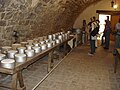
Roquefort Museum in Cornus

.jpg)


Monts
This territory is generally located in the west of the nature park and forms a collective term for several areas, such as the Monts de Lacaune in the southwest, the Ségala around the Tarn river in the west and the Plateau du Lévézou in the northwest. The height of the mountains varies between 300 and 900 meters and culminates at the Puech du Pal summit at 1155 meters. The altitude and the frequent winds form an optimal basis for the use of wind turbines .
- The Monts de Lacaune are in the extreme south of the nature park and continue in the neighboring Haut-Languedoc Regional Nature Park . Depending on the altitude and orientation, their mountain slopes are covered with forests of chestnut , oak and beech . But also numerous conifers, such as spruce and Douglas fir, cover the ridges in the high altitudes of around 1000 meters. The areas in between are used for agriculture. The numerous meandering watercourses head towards the Rance and Dourdou de Camarès rivers .
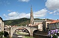
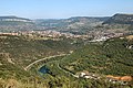
- The Ségala is a landscape that continues outside the nature park in the west. It is a delicately divided landscape of plains and flat valleys. The plateaus and the gently sloping slopes are covered with forage plants and pastures, and oak and chestnut forests are often found on the slopes. Within the nature park, the area extends roughly between the places Lestrades-et-Thouels , Coupiac and Pousthomy . This landscape also includes a section of the Tarn valley called Les Raspes du Tarn . This area is characterized by its abrupt rock breaks into the river valley. Here, too, you will find a large number of chestnut trees, and wine, fruit and vegetables are also grown. The main town is Brousse-le-Château .
- The Plateau du Lévézou is located in the west and north-west of the nature park. A line of high mountain ridges with the peaks Seigne (1128 m) and the Puech du Pal (1155 m) dominates several high plateaus as well as the valleys of the Aveyron and the Muze . The steep slopes are covered by coniferous forests and border on old heathland and beech forests . On the plateaus there are large pastures and cultivated landscapes for sheep breeding on rolling hills and valleys. The border between the Lévézou and the Avant-Causses further south-east forms the valley of the Muze . The places built on these exposed slopes are surrounded by a bocage landscape with hedges based on ash trees. Examples are: Saint-Léons , Saint-Laurent-du-Lévézou , Saint-Beauzély , Castelnau-Pégayrols and Montjaux .

View from the Monts de Lacaune to Murasson

Landscape in the Ségala

Raspes de Tarn
The Tarn at Brousse-le-Château
View from the top of the Lévézou

Wind generators on the ridge of the Lévézou


See also
Web links
- Natural park website (French)