
Camarès
|
Camarès Lo Pont de Camarés |
||
|---|---|---|
.svg)
|
|
|
| region | Occitania | |
| Department | Aveyron | |
| Arrondissement | Millau | |
| Canton | Causses-Rougiers | |
| Community association | Monts, Rance and Rougier | |
| Coordinates | 43 ° 49 ' N , 2 ° 53' E | |
| height | 356-968 m | |
| surface | 41.86 km 2 | |
| Residents | 1,038 (January 1, 2017) | |
| Population density | 25 inhabitants / km 2 | |
| Post Code | 12360 | |
| INSEE code | 12044 | |
 Town hall (Mairie) of Camarès |
||

Camarès ( Occitan : Lo Pont de Camarés ) is a place and a municipality in the south of France with 1,038 inhabitants (as of January 1, 2017) in the Aveyron department in the Occitania region (previously Midi-Pyrénées ). It belongs to the arrondissement of Millau and the canton of Causses-Rougiers (until 2015: canton of Camarès ).
location
Camarès is located about 45 kilometers east-southeast of Albi on the Dourdou de Camarès in the southwest of the historic Rouergue province . Camarès is surrounded by the neighboring communities of Montlaur in the north and north-west, Gissac in the north and north-east, Sylvanès in the east, Fayet in the east and south-east, Brusque in the south-east, Peux-et-Couffouleux in the south and Mounes-Prohencoux in the west and south-west.
Population development
| year | 1962 | 1968 | 1975 | 1982 | 1990 | 1999 | 2006 | 2013 |
| Residents | 1,288 | 1,253 | 1,212 | 1,258 | 1,127 | 1.008 | 983 | 1.008 |
| Source: Cassini and INSEE | ||||||||
Attractions
- Sainte-Croix church from 1869
- Saint-Michel church from 1825
- Chapel of Saint Pierre in Issis
- old bridge from the 11th century
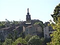
Sainte-Croix church

Saint-Michel church

Saint-Pierre Chapel
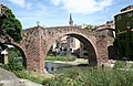
Old bridge


Personalities
- Yves Rouquette (1936-2015), writer