
Vézins-de-Lévézou
|
Vézins-de-Lévézou Vesinh de Leveson |
||
|---|---|---|

|
|
|
| region | Occitania | |
| Department | Aveyron | |
| Arrondissement | Millau | |
| Canton | Raspes et Lévezou | |
| Community association | Lévézou Pareloup | |
| Coordinates | 44 ° 17 ′ N , 2 ° 57 ′ E | |
| height | 713-1,155 m | |
| surface | 78.96 km 2 | |
| Residents | 656 (January 1, 2017) | |
| Population density | 8 inhabitants / km 2 | |
| Post Code | 12780 | |
| INSEE code | 12294 | |

Vézins-de-Lévézou ( Occitan : Vesinh ) is a French commune of the department of Aveyron in the region Occitania (before 2016: Midi-Pyrénées ) with 656 inhabitants (as of January 1 2017). Administratively, it is assigned to the canton of Raspes et Lévezou (until 2015: canton of Vézins-de-Lévézou ) and the arrondissement of Millau . The inhabitants are called Vézinois .
geography
Vézins-de-Lévézou is located about 22 kilometers north-northwest of Millau and about 31 kilometers east-southeast of Rodez in one of the southern foothills of the Massif Central in a wooded region. The Viaur flows through the municipality . The municipality is part of the Grands Causses Regional Nature Park . Vézins-de-Lévézou is surrounded by the neighboring communities of Recoules-Prévinquières in the north, Lavernhe in the northeast, Sévérac-le-Château in the east and northeast, Verrières in the east and southeast, Saint-Léons in the southeast, Saint-Laurent-de-Lévézou in the South, Curan in the south and southwest and Ségur in the west.
Population development
| year | 1962 | 1968 | 1975 | 1982 | 1990 | 1999 | 2006 | 2013 |
|---|---|---|---|---|---|---|---|---|
| Residents | 1,045 | 1.004 | 879 | 809 | 699 | 634 | 643 | 654 |
| Source: Cassini and INSEE | ||||||||
Attractions
- Saint-Amans church, a historic monument since 1991
- Vézins-de-Lévézou castle from the 12th century, alterations from the 17th and 19th centuries, monument historique since 1990
- Tower of the Knights Templar in La Clau
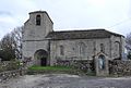
Saint-Amans church

Vézins-de-Lévézou castle

.jpg)