
Viala-du-Tarn
|
Viala-du-Tarn Lo Vialar de Tarn |
||
|---|---|---|
.svg)
|
|
|
| region | Occitania | |
| Department | Aveyron | |
| Arrondissement | Millau | |
| Canton | Tarn et Causses | |
| Community association | Muse et Raspes du Tarn | |
| Coordinates | 44 ° 4 ' N , 2 ° 53' E | |
| height | 300-1,050 m | |
| surface | 38.56 km 2 | |
| Residents | 504 (January 1, 2017) | |
| Population density | 13 inhabitants / km 2 | |
| Post Code | 12490 | |
| INSEE code | 12296 | |
| Website | http://www.vialadutarn.fr/ | |

Viala-du-Tarn ( Occitan : Lo Vialar de Tarn ) is a French commune with 504 inhabitants (as of January 1, 2017) in the Aveyron département and in the Occitania region (before 2016: Midi-Pyrénées ). It belongs to the canton of Tarn et Causses (until 2015: canton of Saint-Beauzély ) and the arrondissement of Millau . The inhabitants are called Vialarains .
location
Viala-du-Tarn is located about 16 kilometers west-southwest of Millau am Tarn . The municipality is part of the Grands Causses Regional Nature Park . Viala-du-Tarn is surrounded by the neighboring communities of Salles-Curan in the north, Montjaux in the east and north-east, Saint-Rome-de-Tarn in the south and south-east, Saint-Victor-et-Melvieu in the south and south-west and Ayssènes in the west.
Population development
| year | 1962 | 1968 | 1975 | 1982 | 1990 | 1999 | 2006 | 2013 |
|---|---|---|---|---|---|---|---|---|
| Residents | 826 | 671 | 581 | 539 | 533 | 525 | 538 | 442 |
| Source: Cassini and INSEE | ||||||||
Attractions
- Dolmen of Cazarède, Monument historique since 1997
- Saint-Saturnin church in Viala
- Saint-Symphorien Church in Saint-Symphorien
- Saint-Pierre church in Ladepeyre
- Saint Martin Church in Coudouls
- Saint-Sauveur Church in Pinet
- Saint-Jacques chapel in Minier
- Notre-Dame chapel in Plescamps
- Chapel of Saint-Etienne in Meilhas
- Remains of the fortifications
- medieval town centers
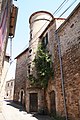
Tower in the village of Viala
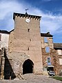
Fortification and gate of Viala

