Réquista
| Réquista | ||
|---|---|---|

|
|
|
| region | Occitania | |
| Department | Aveyron | |
| Arrondissement | Millau | |
| Canton | Monts du Réquistanais | |
| Community association | Réquistanais | |
| Coordinates | 44 ° 2 ′ N , 2 ° 32 ′ E | |
| height | 207-670 m | |
| surface | 59.32 km 2 | |
| Residents | 2,005 (January 1, 2017) | |
| Population density | 34 inhabitants / km 2 | |
| Post Code | 12170 | |
| INSEE code | 12197 | |
| Website | http://www.requista.com/ | |
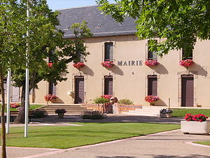
 Réquista Town Hall |
||
Réquista ( Occitan : Requistar ) is a French commune of the department of Aveyron with 2,005 inhabitants (as of January 1 2017) in the region Occitania . It is part of the arrondissement of Millau and the canton of Monts du Réquistanais (until 2015: canton of Réquista ). The inhabitants are called Réquistanais .
geography
Réquista is located about 33 kilometers east-northeast of Albi in the Massif Central . The Tarn River flows south of the municipality. Réquista is surrounded by the neighboring municipalities of La Selve in the north, Durenque in the northeast, Lestrade-et-Thouels in the east, Connac in the east and southeast, Brasc in the south and southeast, Fraissines in the south and southwest, Cadix in the southwest, Le Doum in the west and Southwest and Saint-Jean-Delnous to the west.
The former Routes nationales 602 and 603 run through the municipality .
history
Réquista is a bastide that was founded in 1290/1293.
Population development
| year | 1962 | 1968 | 1975 | 1982 | 1990 | 1999 | 2006 | 2012 |
|---|---|---|---|---|---|---|---|---|
| Residents | 2.405 | 2,482 | 2,625 | 2,512 | 2,243 | 2,060 | 2.118 | 2,020 |
Attractions
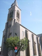
- Réquista Church
- Art museum in the Lincou manor

