
Combret
| Combret | ||
|---|---|---|

|
|
|
| region | Occitania | |
| Department | Aveyron | |
| Arrondissement | Millau | |
| Canton | Causses-Rougiers | |
| Community association | Monts, Rance and Rougier | |
| Coordinates | 43 ° 51 ′ N , 2 ° 40 ′ E | |
| height | 326-919 m | |
| surface | 49.85 km 2 | |
| Residents | 270 (January 1, 2017) | |
| Population density | 5 inhabitants / km 2 | |
| Post Code | 12370 | |
| INSEE code | 12069 | |
| Website | http://www.combret-aveyron.fr/ | |
 Town Hall (Mairie) of Combret |
||

Combret ( identical in Occitan ) is a place and a municipality in the south of France with 270 inhabitants (as of January 1, 2017) in the Aveyron department in the Occitania region (previously Midi-Pyrénées ). Combret belongs to the arrondissement of Millau and the canton of Causses-Rougiers (until 2015: canton of Saint-Sernin-sur-Rance ). The inhabitants are called Combretois .
location
Combret is located about 40 kilometers east-southeast of Albi in the southwest of the historic province of Rouergue am Rance . Combret is surrounded by the neighboring communities of La Serre in the north and north-west, Saint-Juéry in the north, Rebourgil in the north-east, Belmont-sur-Rance in the east, Saint-Sever-du-Moustier in the south and south-west, Laval-Roquecezière in the west and south-west and Saint-Sernin-sur-Rance in the north-west.
Population development
| year | 1962 | 1968 | 1975 | 1982 | 1990 | 1999 | 2006 | 2013 |
| Residents | 532 | 462 | 370 | 327 | 271 | 296 | 294 | 283 |
| Source: Cassini and INSEE | ||||||||
Attractions
- Menhirs
- Saint-Jean-Baptiste church, rebuilt in 1393 on the foundations of a 12th century church, monument historique since 1939
- medieval town center with the rest of the donjon and remains of the castle
- Medieval hall, monument historique since 2004

Bell tower of the Saint-Jean-Baptiste church
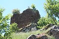
Remains of the castle

medieval hall


