
Midi-Pyrénées
|
Midi-Pyrénées Former French Region (until 2015) |
|

|

|
  |
|
| Basic data | |
|---|---|
| Today part of | Occitania |
| Administrative headquarters | Toulouse |
|
population
- total January 1, 2017 |
3,034,719 inhabitants |
|
surface - total |
45,348 km² |
| Departments | 8th |
| Arrondissements | 22nd |
| Cantons | 293 |
| Communities | 3,020 |
| Formerly ISO 3166-2 code | FR-N |
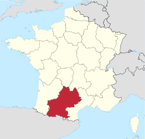
Midi-Pyrénées [ midipireˈne ] was a region in southwest France , which consisted of the departments of Ariège , Aveyron , Haute-Garonne , Gers , Lot , Hautes-Pyrénées , Tarn and Tarn-et-Garonne . It had an area of 45,348 km² and 3,034,719 inhabitants (as of January 1, 2017). The capital of the region was Toulouse .
The name of the region is a new creation made up of Midi ( French for midday , south , also used as a general name for southern France ) and the French name of the Pyrenees (Pyrénées) .
geography
The Midi-Pyrénées region bordered Spain and Andorra to the south, the Aquitaine region to the west, Languedoc-Roussillon to the east, and Auvergne and Limousin to the north .
The region could be divided into three landscape zones: The south was shaped by the high mountain range of the Pyrenees . The northeast and the extreme north belonged to the low mountain range of the Massif Central . The central and northwestern part of the region, however, was flat. It was shaped by the course of the Garonne and its tributaries, which drained most of the region to the Atlantic .
coat of arms
Description: A gold Tolosan cross in red .
history
Today's region is a new creation made up of parts of different historical territories. It was created in 1960 with the establishment of the regions in France. In 1972 the region received the status of an établissement public under the direction of a regional prefect. The decentralization laws of 1982 gave the regions the status of collectivités territoriales ( territorial authorities ), which until then had only been enjoyed by the municipalities and the départements . In 1986 the regional councils were directly elected for the first time. Since then, the region's powers vis-à-vis the central government in Paris have been gradually expanded.
Until 1789 the northern part of the region belonged to the historical province of Guyenne ( Aquitaine ), the southwest to Gascony , the southeast (including the city of Toulouse ) largely to Languedoc , the extreme southeast formed the county of Foix (Comté de Foix) .
The Counts of Toulouse were the most powerful rulers of southern France in the 12th century until they were defeated in the Albigensian Wars. The Cathars or Albigensians had their headquarters in this area.
On January 1, 2016, the Midi-Pyrénées region merged with the neighboring Languedoc-Roussillon region to form the Occitania region .
population
The population distribution of the region is strongly oriented towards the capital Toulouse , in whose agglomeration a third of the population lives. The rest of the region is predominantly small-town and rural.
Cities
The most populous cities in the Midi-Pyrénées region are:
| city | Inhabitants (year) | Department |
|---|---|---|
| Toulouse | 479,553 (2017) | Haute-Garonne |
| Montauban | 60,810 (2017) | Tarn-et-Garonne |
| Albi | 48,970 (2017) | Camouflage |
| Tarbes | 41,518 (2017) | Hautes-Pyrénées |
| Castres | 41,636 (2017) | Camouflage |
| Colomiers | 38,951 (2017) | Haute-Garonne |
| Tournefeuille | 26,962 (2017) | Haute-Garonne |
| Muret | 24,945 (2017) | Haute-Garonne |
| Rodez | 24,057 (2017) | Aveyron |
| Blagnac | 24,517 (2017) | Haute-Garonne |
Political structure
The Midi-Pyrénées region is divided into eight departments :
| Department | prefecture | ISO 3166-2 | Arrondissements | Cantons | Communities | Inhabitants (year) | Area (km²) |
Density (inh / km²) |
||
|---|---|---|---|---|---|---|---|---|---|---|
| Ariège | Foix | FR-09 | 3 | 22nd | 332 |
|
4,890 | 31.3 | ||
| Aveyron | Rodez | FR-12 | 3 | 46 | 304 |
|
8,735 | 32 | ||
| Haute-Garonne | Toulouse | FR-31 | 3 | 53 | 589 |
|
6,309 | 216 | ||
| Gers | Also | FR-32 | 3 | 31 | 463 |
|
6,257 | 30.5 | ||
| Lot | Cahors | FR-46 | 3 | 31 | 340 |
|
5,217 | 33.3 | ||
| Hautes-Pyrénées | Tarbes | FR-65 | 3 | 34 | 474 |
|
4,464 | 51.2 | ||
| Camouflage | Albi | FR-81 | 2 | 46 | 323 |
|
5,758 | 67.4 | ||
| Tarn-et-Garonne | Montauban | FR-82 | 2 | 30th | 195 |
|
3,718 | 69.5 |
economy
In comparison with the GDP of the EU expressed in purchasing power standards, the region achieved an index of 100.2 (EU-27: 100) ( 2004 ). It ranks 11th out of the 26 French regions.
Attractions
- Grotte de Massabielle , Lourdes - an important place of pilgrimage and pilgrimage
- Viaduc de Millau - longest cable-stayed bridge in the world
- Musée des Augustins - Art Museum in Toulouse
- Place du Capitole - Place in Toulouse with the town hall
- Ensemble conventuel des Jacobins - Gothic monastery church in Toulouse
- Albi Cathedral - Gothic cathedral in Albi
- Château de Roquefixade - Castle
- Château de Montségur - castle
- Pyrenees National Park
- Lac de Gaube - clear mountain lake in the Pyrenees
- Mont Perdu - mountains and mountains in the Pyrenees with waterfalls, lakes and gorges
- Pic du Midi - popular mountain in the Pyrenees with an observatory on the summit
- Col du Tourmalet - Mountain Pass of the Pyrenees
- Grotte de Niaux - cave with cave paintings from prehistoric times
- Gouffre de Padirac - underground water with hiking trail
- Grotte de Lombrives - cave complex at Ornolac-Ussat-les-Bains
- Grottes de Gargas - cave and historical site
- Grotte du Pech Merle - cave with rock carvings from around 16-20,000 BC And a museum on prehistory
See also
Web links
- Midi-Pyrénées region (French, partly German)
- Prefecture of the Midi-Pyrénées region (French)
- Midi-Pyrénées: great expanses . France's official website (German)
Individual evidence
- ↑ Regional GDP per inhabitant in the EU25 . Eurostat News Release, 63/2006
Collectivités :
Auvergne-Rhône-Alpes |
Bourgogne-Franche-Comté |
Brittany |
Center-Val de Loire |
Grand Est |
Hauts-de-France |
Île-de-France |
Normandy |
Nouvelle-Aquitaine |
Occitania |
Pays de la Loire |
Provence-Alpes-Cote d'Azur
Collectivité with special status:
Corsica
Overseas Regions (ROM) :
French Guiana |
Guadeloupe |
Martinique |
Mayotte |
Reunion
Former regions (disbanded 2015):
Aquitaine |
Auvergne |
Burgundy |
Champagne-Ardenne |
Alsace |
Franche-Comté |
Languedoc-Roussillon |
Limousin |
Lorraine |
Midi-Pyrénées |
Nord-Pas-de-Calais |
Lower Normandy |
Upper Normandy |
Picardy |
Poitou-Charentes |
Rhône-Alpes
Coordinates: 43 ° 47 ' N , 1 ° 41' E