Muret
| Muret | ||
|---|---|---|

|
|
|
| region | Occitania | |
| Department | Haute-Garonne | |
| Arrondissement | Muret | |
| Canton | Muret (main town) | |
| Community association | Le Muretain Agglo | |
| Coordinates | 43 ° 28 ′ N , 1 ° 20 ′ E | |
| height | 152-305 m | |
| surface | 57.84 km 2 | |
| Residents | 24,945 (January 1, 2017) | |
| Population density | 431 inhabitants / km 2 | |
| Post Code | 31600 | |
| INSEE code | 31395 | |
| Website | http://www.mairie-muret.fr/ | |
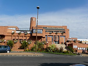
 Town Hall ( Hôtel de ville ) |
||
Muret ( Occitan and Gascon Murèth ) is a French commune with 24,945 inhabitants (as of January 1, 2017) in the Haute-Garonne department in the Occitania region ; it is the administrative seat of the arrondissement of Muret and the capital of the canton of Muret .
The city is located 20 kilometers south of Toulouse at the confluence of the Garonne and Louge rivers .
Population development
- 1962: 6693
- 1968: 13.039
- 1975: 14.778
- 1982: 15,844
- 1990: 18.134
- 1999: 20.735
- 2006: 24,000
- 2017: 24,945
Attractions
- Saint-Jacques church
- Clément Ader Museum
- Park Clément Ader
See also: List of Monuments historiques in Muret
Town twinning
Personalities
- Clément Ader (1841–1925), aviation pioneer and inventor
- Vincent Auriol (1884–1966), Mayor of Muret (1925), President of France
- Nicolas Dalayrac (1753–1809), composer
- Charles de Rémusat (1797–1875), politician and philosopher, MP for the Muret constituency
- Germier of Toulouse , Bishop of Toulouse and saint of the 7th century
- Guillaume Ibos (1860–1952), opera singer
- Marcus Antonius Muretus (1526–1585), humanist
- Adolphe Niel (1802–1869), Marshal of France and Minister of War
See also
- Battle of Muret (September 12, 1213)
literature
- Le Patrimoine des Communes de la Haute-Garonne. Flohic Editions, Volume 2, Paris 2000, ISBN 2-84234-081-7 , pp. 1094-1109.
Web links
Commons : Muret - collection of images, videos and audio files

