
Lautignac
|
Lautignac Lautinhac |
||
|---|---|---|
|
||
| region | Occitania | |
| Department | Haute-Garonne | |
| Arrondissement | Muret | |
| Canton | Cazères | |
| Community association | Coeur de Garonne | |
| Coordinates | 43 ° 23 ' N , 1 ° 3' E | |
| height | 281-351 m | |
| surface | 17.8 km 2 | |
| Residents | 265 (January 1, 2017) | |
| Population density | 15 inhabitants / km 2 | |
| Post Code | 31370 | |
| INSEE code | 31283 | |
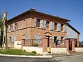
 Lautignac Town Hall (Mairie) |
||

Lautignac ( Occitan : Lautinhac ) is a French commune with 265 inhabitants (as of January 1, 2017) in the Haute-Garonne department in the Occitania region (previously Midi-Pyrénées ). Lautignac belongs to the Arrondissement of Muret and the canton of Cazères . The inhabitants are called Altinacois and Lautignacais .
geography
Lautignac is about 47 kilometers southwest of Toulouse . Lautignac is surrounded by the neighboring communities of Plagnole in the north, Rieumes in the north and north-east, Savères in the east, Labastide-Clermont in the south-east, Pouy-de-Touges in the south and south-west, Montastruc-Savès in the south-west, Sajas in the west and Le Pin-Murelet in the west and northwest.
Population development
| year | 1962 | 1968 | 1975 | 1982 | 1990 | 1999 | 2006 | 2013 |
| Residents | 222 | 205 | 171 | 191 | 201 | 218 | 258 | 282 |
| Source: Cassini and INSEE | ||||||||
Attractions
- Sainte-Philomene Church, built in 1846
- Rectory

Sainte-Philomene Church
Rectory


literature
- Le Patrimoine des Communes de la Haute-Garonne. Flohic Editions, Volume 2, Paris 2000, ISBN 2-84234-081-7 , pp. 1229-1232.
Web links
Commons : Lautignac - collection of images, videos and audio files