Montaut (Haute-Garonne)
| Montaut | ||
|---|---|---|

|
|
|
| region | Occitania | |
| Department | Haute-Garonne | |
| Arrondissement | Muret | |
| Canton | Auterive | |
| Community association | Volvestre | |
| Coordinates | 43 ° 21 ′ N , 1 ° 18 ′ E | |
| height | 175-301 m | |
| surface | 17.88 km 2 | |
| Residents | 506 (January 1, 2017) | |
| Population density | 28 inhabitants / km 2 | |
| Post Code | 31410 | |
| INSEE code | 31361 | |
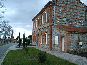
 Town hall (Mairie) of Montaut |
||
Montaut is a French commune with 506 inhabitants (as of January 1, 2017) in the Haute-Garonne department in the Occitanie region . Montaut is part of the Muret arrondissement and the Auterive canton (until 2015: Carbonne canton ). The inhabitants are called Montois or Montaudais .
geography
Montaut is located about eleven kilometers south of Muret the river Lèze , a tributary of the Garonne , which forms the western municipal boundary. Montaut is surrounded by the neighboring communities of Mauzac in the north, Beaumont-sur-Lèze in the northeast, Auribail in the east, Saint-Sulpice-sur-Lèze in the southeast, Montgazin in the south, Marquefave and Capens in the southwest, and Noé in the west.
Population development
| year | 1962 | 1968 | 1975 | 1982 | 1990 | 1999 | 2006 | 2012 |
| Residents | 266 | 250 | 316 | 362 | 374 | 440 | 485 | 519 |
| Source: Cassini and INSEE | ||||||||
Attractions
- Saint-Barthélémy church from the 15th and 19th centuries
literature
- Le Patrimoine des Communes de la Haute-Garonne. Flohic Editions, Volume 1, Paris 2000, ISBN 2-84234-081-7 , pp. 520-522.
Web links
Commons : Montaut - collection of images, videos and audio files
