Louge
| Louge | ||
|
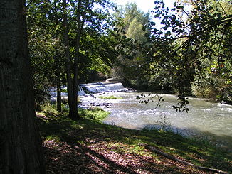
The Louge at Peyssies |
||
| Data | ||
| Water code | FR : O09-0400 | |
| location | France , Occitania region | |
| River system | Garonne | |
| Drain over | Garonne → Atlantic Ocean | |
| source | in the municipal area of Villeneuve-Lécussan 43 ° 7 ′ 6 ″ N , 0 ° 28 ′ 21 ″ E |
|
| Source height | approx. 560 m | |
| muzzle | in the urban area of Muret in the Garonne Coordinates: 43 ° 27 ′ 43 " N , 1 ° 19 ′ 58" E 43 ° 27 ′ 43 " N , 1 ° 19 ′ 58" E |
|
| Mouth height | approx. 150 m | |
| Height difference | approx. 410 m | |
| Bottom slope | approx. 4.1 ‰ | |
| length | 100 km | |
| Left tributaries | Nère | |
| Medium-sized cities | Muret | |
The Louge is a river in France that runs in the Haute-Garonne department in the Occitanie region . It rises on the plateau of Lannemezan , in the municipality of Villeneuve-Lécussan , generally drains north-east and flows into the Garonne after 100 kilometers in the urban area of Muret as a left tributary . Since it has little water in dry periods, it is - like most rivers on the Lannemezan plateau - artificially irrigated; in their case through the Canal de Saint-Martory and the Rigole de la Louge , which in turn draws its water from the Canal de la Neste .
The water in the Louge itself is also diverted for irrigation through channels, such as B. by the Canal de Franquevielle à Cardeilhac .
Places on the river
Web links
Remarks
- ↑ Source geoportail.gouv.fr
- ↑ estuary geoportail.gouv.fr
- ↑ a b Louge at SANDRE (French)
