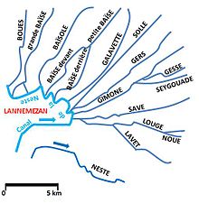
Lannemezan Plateau
The Lannemezan Plateau is a plateau in southern France . It is located in the Hautes-Pyrénées department and is populated by around 10,000 people.
geography
The plateau is located at the foot of the Pyrenees , roughly between the cities of Tarbes and Saint-Gaudens . In its center lies the town of Lannemezan , which gave the plateau its name. The plateau has an average height of about 510 meters.
Hydrology
The area is rich in water sources and a large number of rivers and streams have their source here. The Garonne river system includes:
The drains to the Adour river system
Since the rivers often suffer from poor water flow in dry periods, they are artificially irrigated via a sophisticated canal system . The Canal de la Neste serves as a kind of ring distributor , from which other canals and irrigation channels branch off and thus supply a large number of rivers with additional water.
Coordinates: 43 ° 10 ′ 0 ″ N , 0 ° 23 ′ 0 ″ E

