Gimone
| Gimone | ||
|
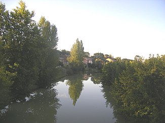
The Gimone at Larrazet |
||
| Data | ||
| Water code | FR : 02-0330 | |
| location | France , Occitania region | |
| River system | Garonne | |
| Drain over | Garonne → Atlantic Ocean | |
| source | in the municipality of Saint-Loup-en-Comminges, 43 ° 14 ′ 13 ″ N , 0 ° 33 ′ 6 ″ E |
|
| Source height | approx. 455 m | |
| muzzle | in the municipality of Castelferrus in the Garonne Coordinates: 44 ° 0 ′ 51 ″ N , 1 ° 6 ′ 18 ″ E, 44 ° 0 ′ 51 ″ N , 1 ° 6 ′ 18 ″ E |
|
| Mouth height | approx. 73 m | |
| Height difference | approx. 382 m | |
| Bottom slope | approx. 2.8 ‰ | |
| length | 136 km | |
| Discharge at the Garganvillar A Eo gauge : 827 km² |
MQ Mq |
2.9 m³ / s 3.5 l / (s km²) |
| Left tributaries | Lauze , Baysole | |
| Right tributaries | Marcaoue , Sarrampion | |
| Reservoirs flowed through | Lac de la Gimone | |
The Gimone is a river in France that runs in the Occitania region . It rises on the plateau of Lannemezan , in the municipality of Saint-Loup-en-Comminges , generally drains north to northwest and flows into the Garonne after 136 kilometers in the municipality of Castelferrus , just south of Castelsarrasin , as a left tributary . On her way she touches the Haute-Garonne , Hautes-Pyrénées , Gers and Tarn-et-Garonne departments . Since it has little water in dry periods, it is - like most rivers on the Lannemezan plateau - artificially irrigated; in their case through the Canal de la Gimone et de l'Arrats , which in turn draws its water from the Canal de la Neste .
Places on the river
(Order in flow direction)
Web links
Commons : Gimone - collection of images, videos and audio files
Individual evidence
- ↑ a b geoportail.fr (1: 16,000)
- ↑ a b The information on the length of the river is based on the information about the Gimone at SANDRE (French), accessed on October 1, 2009, rounded to full kilometers.
- ↑ hydro.eaufrance.fr (station: O2883310 , option: Synthèse ) .
