
Limousin
|
Limousin Former French Region (until 2015) |
|

|

|
  |
|
| Basic data | |
|---|---|
| Today part of | Nouvelle-Aquitaine |
| Administrative headquarters | Limoges |
|
population
- total January 1, 2017 |
734,528 inhabitants |
|
surface - total |
16,942 km² |
| Departments | 3 |
| Arrondissements | 8th |
| Cantons | 106 |
| Communities | 747 |
| Formerly ISO 3166-2 code | FR-L |
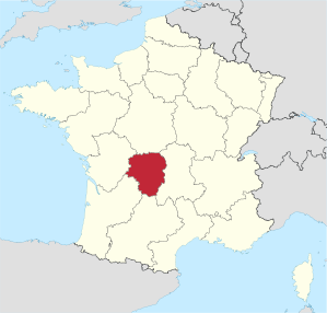
The Limousin [ limuˈzɛ̃ ] ( Occitan Lemosin ) was a region in central France and in the north-western part of the Massif Central . It consisted of the departments of Corrèze , Creuse and Haute-Vienne . With an area of 16,942 km² and 734,528 inhabitants (as of January 1, 2017) the Limousin was one of the most sparsely populated regions in France. The capital of the region was Limoges .
geography
The most important river is the Vienne , on which Limoges is also located. The landscape is already partly quite hilly. The Monts du Limousin are located in the southern part and then to the east the higher plateau de Millevaches , both of which belong to the Massif Central.
coat of arms
Description: Six rows of black ermine interspersed in white with a red border .
history
Traces of mining in the Limousin go back to the 5th century BC. BC back.
In the 7th century the area came under Frankish rule and later split into several vice-counties, which for centuries were ruled by the House of Anjou-Plantagenet . In 1607 it fell under the direct control of the French crown. The northern part of the country is made up of the historic La Marche landscape .
With the establishment of the regions in France in 1960, the Limousin region was created within the boundaries valid until 2016. In 1972 the region received the status of an établissement public under the direction of a regional prefect. The decentralization laws of 1982 gave the regions the status of collectivités territoriales ( territorial authorities ), which until then had only been enjoyed by the municipalities and the départements . In 1986 the regional councils were directly elected for the first time. Since then, the region's powers vis-à-vis the central government in Paris have been gradually expanded.
On January 1, 2016, the Limousin region was merged with the neighboring regions of Aquitaine and Poitou-Charentes to form a new region called Nouvelle-Aquitaine ("New Aquitaine").
population
Cities
The most populous cities of the Limousin are:
| city | Inhabitants (year) | Department |
|---|---|---|
| Limoges | 132,175 (2017) | Haute-Vienne |
| Brive-la-Gaillarde | 46,916 (2017) | Corrèze |
| Grommet | 14,836 (2017) | Corrèze |
| Guéret | 13,161 (2017) | Creuse |
| Saint-Junien | 11,202 (2017) | Haute-Vienne |
| Panazol | 10,972 (2017) | Haute-Vienne |
language
The historical language of the region is Limousin, a variety (a dialect) of Occitan in which some troubadours have also written their poetry.
Political structure
The Limousin region is divided into three departments :
| Department | prefecture | ISO 3166-2 | Arrondissements | Cantons | Communities | Inhabitants (year) | Area (km²) |
Density (inh / km²) |
||
|---|---|---|---|---|---|---|---|---|---|---|
| Corrèze | Grommet | FR-19 | 3 | 37 | 286 |
|
5,857 | 41.2 | ||
| Creuse | Guéret | FR-23 | 2 | 27 | 260 |
|
5,565 | 21.3 | ||
| Haute-Vienne | Limoges | FR-87 | 3 | 42 | 201 |
|
5,520 | 67.8 |
economy
Compared with the GDP of the EU expressed in purchasing power standards reached the region in 2006 an index of 89.5 (EU-27 = 100).
partnership
In 1981, the Middle Franconia district was the first region in Bavaria to enter into a partnership with the Haute-Vienne department in France; In the following years, corresponding agreements followed with the two neighboring departments of Creuse and Corrèze. In 1995 this resulted in a partnership between the (entire) region of Limousin and the district of Middle Franconia.
See also
Web links
- Limousin region (French)
- Prefecture of the Limousin region (French)
- Limousin: The water tower of France's official website (German)
Individual evidence
Collectivités :
Auvergne-Rhône-Alpes |
Bourgogne-Franche-Comté |
Brittany |
Center-Val de Loire |
Grand Est |
Hauts-de-France |
Île-de-France |
Normandy |
Nouvelle-Aquitaine |
Occitania |
Pays de la Loire |
Provence-Alpes-Cote d'Azur
Collectivité with special status:
Corsica
Overseas Regions (ROM) :
French Guiana |
Guadeloupe |
Martinique |
Mayotte |
Reunion
Former regions (disbanded 2015):
Aquitaine |
Auvergne |
Burgundy |
Champagne-Ardenne |
Alsace |
Franche-Comté |
Languedoc-Roussillon |
Limousin |
Lorraine |
Midi-Pyrénées |
Nord-Pas-de-Calais |
Lower Normandy |
Upper Normandy |
Picardy |
Poitou-Charentes |
Rhône-Alpes
Coordinates: 45 ° 54 ' N , 1 ° 44' E