
Peux-et-Couffouleux
|
Peux-et-Couffouleux Pèus e Cofolèus |
||
|---|---|---|
|
||
| region | Occitania | |
| Department | Aveyron | |
| Arrondissement | Millau | |
| Canton | Causses-Rougiers | |
| Community association | Monts, Rance and Rougier | |
| Coordinates | 43 ° 46 ' N , 2 ° 53' E | |
| height | 595–1,092 m | |
| surface | 21.71 km 2 | |
| Residents | 87 (January 1, 2017) | |
| Population density | 4 inhabitants / km 2 | |
| Post Code | 12360 | |
| INSEE code | 12179 | |
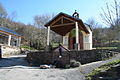
 View of Couffouleux |
||

Peux-et-Couffouleux ( Occitan Pèus e Cofolèus ) is a southern French municipality with 87 inhabitants (as of January 1, 2017) in the Aveyron department in the Occitania region (before 2016 Midi-Pyrénées ). Peux-et-Couffouleux belongs to the Arrondissement of Millau and the canton of Causses-Rougiers ( Camarès until 2015 ). The inhabitants are called Peulussia .
The municipality of Blanc belongs to the municipality .
location
Peux-et-Couffouleux is located about 57 kilometers east-southeast of Albi in the southwest of the historic province of Rouergue . Peux-et-Couffouleux is surrounded by the neighboring communities of Camarès in the north, Brusque in the east, Murat-sur-Vèbre in the south, Murasson in the west and Mounes-Prohencoux in the north-west.
Population development
| year | 1962 | 1968 | 1975 | 1982 | 1990 | 1999 | 2006 | 2013 |
| Residents | 270 | 235 | 190 | 162 | 138 | 109 | 110 | 97 |
| Source: Cassini and INSEE | ||||||||
Attractions
- Saint Nazaire Church in Couffouleux
- Saint-Méen chapel
- Saint-Jean in Blanc church
- Blanc castle ruins

Saint-Nazaire church

Saint-Jean church
Saint-Méen chapel
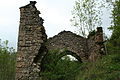
Chapel of the castle ruins


