
Ségur (Aveyron)
|
Ségur Segur |
||
|---|---|---|

|
|
|
| region | Occitania | |
| Department | Aveyron | |
| Arrondissement | Millau | |
| Canton | Raspes et Lévezou | |
| Community association | Lévézou Pareloup | |
| Coordinates | 44 ° 18 ′ N , 2 ° 50 ′ E | |
| height | 716-1,005 m | |
| surface | 67.05 km 2 | |
| Residents | 557 (January 1, 2017) | |
| Population density | 8 inhabitants / km 2 | |
| Post Code | 12290 | |
| INSEE code | 12266 | |

Ségur ( Occitan : Segur ) is a French commune of the department of Aveyron in the region Occitania (before 2016: Midi-Pyrénées ) with 557 inhabitants (as of January 1 2017). Administratively, it is assigned to the canton of Raspes et Lévezou (until 2015: canton of Vézins-de-Lévézou ) and the arrondissement of Millau . The inhabitants are called Ségurois .
geography
Ségur is located about 29 kilometers northwest of Millau and about 21 kilometers east-southeast of Rodez in one of the southern foothills of the Massif Central in a wooded region on the Viaur . The municipality is part of the Grands Causses Regional Nature Park . Ségur is surrounded by the neighboring communities of Arques in the north and north-west, Laissac and Sévérac-l'Église in the north, Gaillac-d'Aveyron in the north-east, Vézins-de-Lévézou in the east, Curan in the south, Prades-Salars in the south and south-west, Pont-de-Salars in the west and Le Vibal in the northwest.
Population development
| year | 1962 | 1968 | 1975 | 1982 | 1990 | 1999 | 2006 | 2013 |
|---|---|---|---|---|---|---|---|---|
| Residents | 1,031 | 896 | 803 | 738 | 662 | 623 | 595 | 579 |
| Source: Cassini and INSEE | ||||||||
Attractions
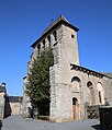
- Saint-Agnan church, priory church from the 12th century, monument historique since 1979
- Church of Saint-Étienne in Saint-Étienne-de-Viauresque from the 12th century, monument historique since 1979
- Saint-Pierre church
- Gallo-Roman sarcophagus, monument historique since 1942

Saint-Agnan Church
Saint-Etienne church

