
Sainte-Eulalie-de-Cernon
|
Sainte-Eulalie-de-Cernon Senta Aulària de Sarnon |
||
|---|---|---|
.svg)
|
|
|
| region | Occitania | |
| Department | Aveyron | |
| Arrondissement | Millau | |
| Canton | Causses-Rougiers | |
| Community association | Larzac et Vallées | |
| Coordinates | 43 ° 59 ′ N , 3 ° 8 ′ E | |
| height | 529-912 m | |
| surface | 46.35 km 2 | |
| Residents | 286 (January 1, 2017) | |
| Population density | 6 inhabitants / km 2 | |
| Post Code | 12230 | |
| INSEE code | 12220 | |
 View of Sainte-Eulalie-de-Cernon |
||

Sainte-Eulalie-de-Cernon ( Occitan : Senta Aulària de Sarnon ) is a place and a municipality in the south of France with 286 inhabitants (as of January 1, 2017) in the Aveyron department in the Occitania region (previously Midi-Pyrénées ). Belmont-sur-Rance belongs to the Arrondissement of Millau and the canton of Causses-Rougiers (until 2015: canton of Cornus ). The inhabitants are called Saint-Eulaliens .
location
Sainte-Eulalie-de-Cernon is about 13 kilometers south-southeast of Millau in the southwest of the historic Rouergue province . Sainte-Eulalie-de-Cernon is surrounded by the neighboring communities of La Cavalerie in the north and northeast, L'Hospitalet-du-Larzac in the east, La Couvertoirade in the east and southeast, Cornus in the southeast, Saint-Beaulize in the south, and Saint-Jean- et-Saint-Paul in the south-west, Viala-du-Pas-de-Jaux in the west and south-west and Lapanouse-de-Cernon in the west and north-west.
Population development
| year | 1962 | 1968 | 1975 | 1982 | 1990 | 1999 | 2006 | 2013 |
| Residents | 276 | 248 | 253 | 230 | 219 | 221 | 240 | 263 |
| Source: Cassini and INSEE | ||||||||
Attractions
- Rafènes dolmen
- Les Mortes burial mounds
- Sainte-Eulalie church from the 12th century, a historic monument since 1927
- Commander of the Knights Templar, Monument historique since 1976
- Site fortification
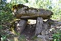
Rafènes dolmen

Sainte-Eulalie church

Commander of the Knights Templar


