
Brusque (Aveyron)
|
Brusque Brusca |
||
|---|---|---|
.svg)
|
|
|
| region | Occitania | |
| Department | Aveyron | |
| Arrondissement | Millau | |
| Canton | Causses-Rougiers | |
| Community association | Monts, Rance and Rougier | |
| Coordinates | 43 ° 46 ′ N , 2 ° 57 ′ E | |
| height | 416–1,080 m | |
| surface | 36.18 km 2 | |
| Residents | 276 (January 1, 2017) | |
| Population density | 8 inhabitants / km 2 | |
| Post Code | 12360 | |
| INSEE code | 12039 | |
 Town Hall (Mairie) and Brusque School |
||

Brusque ( Occitan : Brusca ) is a place and a municipality in the south of France with 276 inhabitants (as of January 1, 2017) in the Aveyron department in the Occitania region (previously Midi-Pyrénées ). Brusque belongs to the arrondissement of Millau and the canton of Causses-Rougiers (until 2015: canton of Camarès ). The inhabitants are called Brusquois .
location
Brusque is located about 46 kilometers east-southeast of Albi on the Dourdou de Camarès in the southwest of the historic Rouergue province . Brusque is surrounded by the neighboring communities of Fayet in the north and northeast, Tauriac-de-Camarès in the east, Mélagues in the east and southeast, Arnac-sur-Dourdou in the south, Murat-sur-Vèbre in the southwest, Peux-et-Couffouleux in the west as well Camarès in the northwest.
Population development
| year | 1962 | 1968 | 1975 | 1982 | 1990 | 1999 | 2006 | 2013 |
| Residents | 545 | 594 | 540 | 527 | 422 | 366 | 326 | 293 |
| Source: Cassini and INSEE | ||||||||
Attractions
- Saint Martin Church
- Remains of the former Saint-Jacques church in Le Castellat
- Castle ruins
- Old bridge
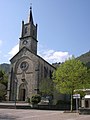
Saint Martin Church
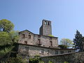
Castle ruins

Old bridge


Personalities
- André Gouzes (* 1943), church musician