Gissac
| Gissac | ||
|---|---|---|
|
|
||
| region | Occitania | |
| Department | Aveyron | |
| Arrondissement | Millau | |
| Canton | Causses-Rougiers | |
| Community association | Monts, Rance and Rougier | |
| Coordinates | 43 ° 48 ' N , 2 ° 57' E | |
| height | 351-769 m | |
| surface | 31.02 km 2 | |
| Residents | 103 (January 1, 2017) | |
| Population density | 3 inhabitants / km 2 | |
| Post Code | 12360 | |
| INSEE code | 12109 | |
Gissac ( identical in Occitan ) is a place and a municipality in the south of France with 103 inhabitants (as of January 1, 2017) in the Aveyron department in the Occitania region (until 2015 Midi-Pyrénées ). Gissac is part of the Millau arrondissement and the Causses-Rougiers canton (until 2015: Camarès canton ). The inhabitants are called Gissacois .
location
Gissac is located about 47 kilometers east-southeast of Albi in the southwest of the historic Rouergue province . Gissac is surrounded by the neighboring communities of Saint-Affrique in the north, Versols-et-Lapeyre in the east and northeast, Saint-Félix-de-Sorgues in the east, Sylvanès in the southeast, Camarès in the south, Montlaur in the west and Vabres-l'Abbaye in the Northwest.
Population development
| year | 1962 | 1968 | 1975 | 1982 | 1990 | 1999 | 2006 | 2013 |
| Residents | 154 | 146 | 117 | 152 | 139 | 97 | 110 | 106 |
| Source: Cassini and INSEE | ||||||||
Attractions
- Saint-Jean-Baptiste church
- Gissac Castle from the 19th century
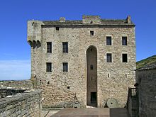
- Montaigut castle from the 10th century, monument historique since 1987
Web links
Commons : Gissac - collection of images, videos and audio files

