
La Couvertoirade
| La Couvertoirade | ||
|---|---|---|
|
||
| region | Occitania | |
| Department | Aveyron | |
| Arrondissement | Millau | |
| Canton | Causses-Rougiers | |
| Community association | Larzac et Vallées | |
| Coordinates | 43 ° 55 ' N , 3 ° 19' E | |
| height | 640-900 m | |
| surface | 61.91 km 2 | |
| Residents | 188 (January 1, 2017) | |
| Population density | 3 inhabitants / km 2 | |
| Post Code | 12230 | |
| INSEE code | 12082 | |
| Website | La Couvertoirade | |
 La Couvertoirade - View of the town |
||

La Couvertoirade ( Occitan La Cobertoirada ) is a French commune with 188 inhabitants (as of January 1, 2017) in the Aveyron department in the Occitanie region . La Couvertoirade is classified as one of the Plus beaux villages de France ( Most Beautiful Villages in France ).
Location and climate
The municipality of La Couvertoirade is part of the Grands Causses Regional Nature Park and is located on the edge of the Cevennes , the south-western foothills of the Massif Central , in the southern area of the Causse du Larzac plateau at an altitude of approx. 775 m . The place is between Millau in the north-west (approx. 41 km driving distance) and Montpellier (a good 75 km) in the south-east. The climate is temperate to warm; Rain (approx. 790 mm / year) falls over the year.
Population development
| year | 1800 | 1851 | 1901 | 1954 | 1999 | 2015 |
| Residents | 815 | 1,020 | 519 | 160 | 153 | 186 |
The population decline since the middle of the 19th century is mainly due to the phylloxera crisis in viticulture and the mechanization of agriculture .
economy
For centuries, the population of the village lived on the rather meager yields of their fields and gardens as self-sufficiency ; a little wine was also grown. Sheep and goats were raised to produce milk and cheese, as well as wool and meat. Since the 1960s, tourism has been added as a source of income in the form of renting holiday apartments ( gîtes ) .
history
The name of the place has been known as Cubertoirata since the 11th century as part of the demarcation of lands of the former abbey of Gellone in Saint-Guilhem-le-Désert ( Hérault ). Since the 12th century, the Templars settled in the village and the surrounding area and made La Couvertoirade a fortified Commendatarabbey of their order. Around the castle a center of agriculture and cattle breeding (horses and sheep) developed under the Knights Templar.
When the Knights Templar was dissolved in 1312 and new rulers took over the place, in 1328 a total of 135 households (fireplaces) with around 600 inhabitants were counted. In the middle of the 14th century the defenses of the place were strengthened again, as armed robber bands plundered the area of Larzac.
In 1562, at the beginning of the Wars of Religion , the Huguenots tried to occupy La Couvertoirade in vain. In 1702 the population armed themselves again and reinforced the gates in order to successfully defend themselves against the attack by the camisards . In 1768 La Couvertoirade was raised to independent command by the Chevalier Riqueti , Baron (French Compte ) of Mirabeau.
Attractions
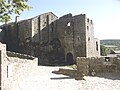
- City fortifications from the 15th and partially from the 12th century such as city walls, defense towers and keep
- Castle Château de Belvezet 18th century
- Saint-Christol church from the 14th century
- Ruins of a pre-Romanesque church of Saint-Christol from the 11th century
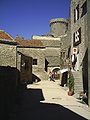
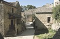
- medieval well-preserved streets of the village

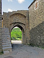
completely preserved north gate / Portal d'Amoun (out of town)

North gate (inner town)


Saint-Christol Church

Interior of the church

Partially restored south gate / Portal d'Abal (out of town)
Partially restored south gate (inner city)


Web links
- Official website of the municipality
- 360 ° panorama - virtual guided tour
- Location of the municipality on Google Maps
Individual evidence
- ↑ La Couvertoirade in Les plus Beaux Villages de France (French)
- ↑ La Couvertoirade - climate tables
- ↑ La Couvertoirade - History