Villefranche-de-Conflent
|
Villefranche-de-Conflent Vilafranca de Conflent |
||
|---|---|---|

|
|
|
| region | Occitania | |
| Department | Pyrénées-Orientales | |
| Arrondissement | Prades | |
| Canton | Les Pyrénées Catalanes | |
| Community association | Conflent-Canigó | |
| Coordinates | 42 ° 35 ' N , 2 ° 22' E | |
| height | 390-1,395 m | |
| surface | 4.46 km 2 | |
| Residents | 213 (January 1, 2017) | |
| Population density | 48 inhabitants / km 2 | |
| Post Code | 66500 | |
| INSEE code | 66223 | |
| Website | www.villefranchedeconflent.fr | |
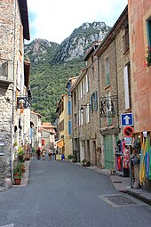
 View of Villefranche-de-Conflent |
||
Villefranche-de-Conflent ( Catalan Vilafranca de Conflent ) is a French commune with 213 inhabitants (as of January 1, 2017) in the Pyrenees , at the northern foot of the Pic du Canigou on the banks of the Têt . It is located in the Occitania region (before 2016 Languedoc-Roussillon ) in the Pyrénées-Orientales department , about 50 km west of Perpignan and about 5 km west of Prades . The municipality is part of the Pyrénées Catalanes Regional Natural Park .
history
Villefranche-de-Conflent was founded in 1092 by Guillem Ramon, Count of Cerdagne , to protect the Têt, Cady and Rotja valleys against invasions. In the same year, the Bishop of Elne gave permission to build the Saint-Jacques church. In 1095 the place received tax privileges and the name Vila Franca . At that time it had an urban character and was the capital of the Conflent region . Villefranche always had a military role. The oldest fortifications date from the 11th century. They were supplemented by eight towers in the 12th century and reinforced by six bastions in the 17th century .
| Population development | ||||||||
|---|---|---|---|---|---|---|---|---|
| year | 1962 | 1968 | 1975 | 1982 | 1990 | 1999 | 2009 | |
| Residents | 580 | 507 | 435 | 294 | 225 | 237 | 232 | |
Villefranche has lost more than half of its population in just under 50 years.
Attractions
- Villefranche-de-Conflent has been named one of the most beautiful villages in France by the association Les Plus Beaux Villages de France .
- The medieval city wall. Its beginnings date back to the 11th century, from 1681 it was expanded and raised. It has been completely preserved to this day.
- The 12th century church of Saint-Jacques with two parallel naves .
- Fort Libéria rises above the city, 734 underground steps . The fortress was built in 1681 by the famous fortress builder Vauban and under Napoléon III. expanded. In the course of time it housed a women's prison, among other things. In 2008 Vauban inscribed the fort along with other fortifications on the UNESCO World Heritage List .
- A well-known tourist attraction is the nearby Grotto des Canalettes .
traffic

The place is on the national road 116 from Perpignan to Bourg-Madame . Departementsstrasse 116 begins on the eastern edge of the village and leads to nearby Vernet-les-Bains .
The Villefranche - Vernet-les-Bains train station is on the north-eastern edge of the town. There send the standard gauge railway line from Perpignan and from Latour-de-Carol coming Schmalspurbahn Ligne de Cerdagne . It was possible to change between the local trains from Perpignan and the yellow narrow-gauge trains of the Petit train jaune on the same platform. The train service to and from Perpignan has been suspended until further notice. Regional buses also run regularly to and from Perpignan Gare Routiere .
Web links
Individual evidence
- ↑ Homepage of Villefranche-de-Conflent ( Memento of January 7, 2015 in the Internet Archive )
- ↑ Villefranche-de-Conflent. In: Les plus Beaux Villages de France. Retrieved January 30, 2020 (French).
- ↑ Michelin Guide de Tourisme Pyrénées Rousillon , 1986 edition, p. 136.


