
Pyrénées Catalanes Regional Natural Park

The Regional Natural Park Pyrénées Catalanes ( French Parc naturel régional des Pyrénées Catalanes ) is located in the French department Pyrénées-Orientales , in the Occitania region . It borders Andorra in the west, Spain in the south and extends from the summit chain of the eastern Pyrenees to the eastern Pyrenees foothills at an altitude of around 300 to 3000 meters. Drainage takes place in the far west by the Ariège river , in the north and east by the rivers Aude and Têt and in the south by the Sègre , which is part of the Ebro river system .
The natural park includes the historical areas of Haut-Conflent , Capcir and Cerdagne , which were formerly part of Northern Catalonia . As a traditional border area, there is also a variety of fortifications here . Particularly noteworthy in this context are Fort Libéria , above Villefranche-de-Conflent , and the Citadel of Mont-Louis , both of which were built by the fortress architect Vauban and are classified as World Heritage Sites .
The park administration is based in Mont-Louis ( 42 ° 30 ′ 32 ″ N , 2 ° 7 ′ 19 ″ E ) Olette planned. The nature park was founded in 2004, covers an area of around 137,000 hectares and a catchment area of around 23,000 inhabitants. The nature park consists of 64 communities. A tourist attraction is the railway line that opens up the area, the Ligne de Cerdagne . It runs between the towns of Villefranche-de-Conflent and Latour-de-Carol and is also known as Train Jaune because of its bright yellow painted wagons .
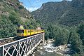
The Jaune train crosses the Têt

Lac du Lanoux
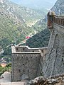
View from Fort Libéria


