Millas
|
Millas Millars |
||
|---|---|---|
|
|
||
| region | Occitania | |
| Department | Pyrénées-Orientales | |
| Arrondissement | Prades | |
| Canton | La Vallée de la Têt | |
| Community association | Roussillon-Conflent | |
| Coordinates | 42 ° 42 ′ N , 2 ° 42 ′ E | |
| height | 89-500 m | |
| surface | 19.12 km 2 | |
| Residents | 4,279 (January 1, 2017) | |
| Population density | 224 inhabitants / km 2 | |
| Post Code | 66170 | |
| INSEE code | 66108 | |
| Website | http://www.mairie-millas.fr/ | |
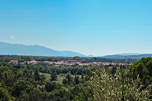
 View of Millas |
||
Millas ( Catalan: Millars ) is a French commune in the department of Pyrenees-Orientales in the region Occitania . The municipality has an area of 19.12 km² and has 4279 inhabitants (as of January 1, 2017). Millas belongs to the Arrondissement of Prades and the canton of La Vallée de la Têt . The inhabitants are called Millassois (es) .
geography
Millas is located in the Ribéral region on the right bank of the Têt River , into which the Bolès flows here. The wine-growing regions Rivesaltes and Côtes du Roussillon (also Côtes du Roussillon-Villages ) extend into the municipality . The best-known product is the Muscat de Rivesaltes . Millas is surrounded by the neighboring communities of Montner in the north, Corneilla-la-Rivière and Saint-Féliu-d'Amont in the east, Camélas in the southeast, Corbère-les-Cabanes and Corbère in the south, Ille-sur-Têt in the southwest, Néfiach in the West and Bélesta to the northwest.
Route nationale 116 and the former route nationale 614 run through the municipality . The station is on the Perpignan – Villefranche-de-Conflent line .
Population development
| 1962 | 1968 | 1975 | 1982 | 1990 | 1999 | 2006 | 2011 |
|---|---|---|---|---|---|---|---|
| 2,453 | 2,489 | 2,569 | 2,824 | 3,091 | 3,452 | 3,766 | 4,005 |
Attractions
- Sainte-Eulalie church, Romanesque church, monument historique since 1965
Personalities
- Christian Bourquin (1954–2014), politician, temporarily Mayor of Millas (1995–2001)
