Camelas
| Camelas | ||
|---|---|---|
|
|
||
| region | Occitania | |
| Department | Pyrénées-Orientales | |
| Arrondissement | Ceret | |
| Canton | Les Aspres | |
| Community association | Aspres | |
| Coordinates | 42 ° 38 ′ N , 2 ° 41 ′ E | |
| height | 118-520 m | |
| surface | 12.72 km 2 | |
| Residents | 464 (January 1, 2017) | |
| Population density | 36 inhabitants / km 2 | |
| Post Code | 66300 | |
| INSEE code | 66033 | |
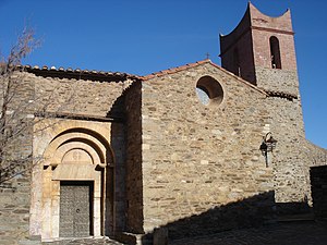
 The Saint-Fructueux church |
||
Camélas is a French commune with 464 inhabitants (as of January 1, 2017) in the Pyrénées-Orientales department in the Occitanie region . It belongs to the Arrondissement of Céret and the canton of Les Aspres .
geography
Neighboring communities
Neighboring municipalities of Camélas are Millas in the north, Saint-Féliu-d'Aumont in the northeast, Castelnou in the southeast, Caixas in the southwest, Corbère in the west and Corbère-les-Cabanes in the northwest.
Population development
| year | 1962 | 1968 | 1975 | 1982 | 1990 | 1999 | 2013 |
| Residents | 313 | 289 | 268 | 308 | 323 | 396 | 428 |
Attractions
- Saint-Fructueux church ( Monument historique )
- Chapel of Saint Martin in La Roca
- Saint-Michel church in Vallcrosa
- Dolmen Caixeta (Monument historique)
Web links
Commons : Camélas - collection of images, videos and audio files

