Terrats
| Terrats | ||
|---|---|---|
|
|
||
| region | Occitania | |
| Department | Pyrénées-Orientales | |
| Arrondissement | Ceret | |
| Canton | Les Aspres | |
| Community association | Aspres | |
| Coordinates | 42 ° 37 ' N , 2 ° 46' E | |
| height | 101-230 m | |
| surface | 7.32 km 2 | |
| Residents | 640 (January 1, 2017) | |
| Population density | 87 inhabitants / km 2 | |
| Post Code | 66300 | |
| INSEE code | 66207 | |
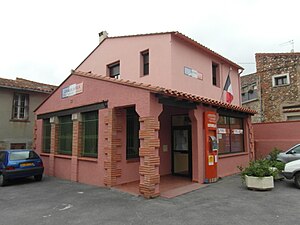
 Terrats Town Hall |
||
Terrats is a French commune in the department of Pyrenees-Orientales in the region Occitania . Administratively it is assigned to the canton of Les Aspres (until 2015: canton of Thuir ) and the arrondissement of Céret . The 640 inhabitants (as of January 1, 2017) are called Terrassous .
geography
Terrats is about 13 kilometers southwest of Perpignan on the Cantarana River . Terrats is surrounded by the neighboring communities of Sainte-Colombe-de-la-Commanderie in the north and northwest, Llupia in the north and northeast, Trouillas in the east, Fourques in the south, Montauriol in the southwest and Castelnou in the west. The wine-growing regions of Rivesaltes and Côtes du Roussillon extend into the municipality .
Population development
| year | 1962 | 1968 | 1975 | 1982 | 1990 | 1999 | 2006 | 2012 |
|---|---|---|---|---|---|---|---|---|
| Residents | 318 | 363 | 366 | 492 | 520 | 528 | 605 | 668 |
| Source: Cassini and INSEE | ||||||||
Attractions
- Romanesque church of Saint-Julien-Sainte-Basilisse from the 11th century
Personalities
- Joan-Lluís Lluís (born 1963), Catalan writer
Web links
Commons : Terrats - collection of images, videos and audio files
