Les Cluses
| Les Cluses | ||
|---|---|---|
|
|
||
| region | Occitania | |
| Department | Pyrénées-Orientales | |
| Arrondissement | Ceret | |
| Canton | Vallespir-Albères | |
| Community association | Vallespir | |
| Coordinates | 42 ° 29 ′ N , 2 ° 50 ′ E | |
| height | 103-368 m | |
| surface | 8.91 km 2 | |
| Residents | 242 (January 1, 2017) | |
| Population density | 27 inhabitants / km 2 | |
| Post Code | 66480 | |
| INSEE code | 66063 | |
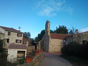
 La Cluse Haute |
||
Les Cluses is a French commune with 242 inhabitants (as of January 1, 2017) in the Pyrénées-Orientales department in the Occitanie region . It belongs to the Arrondissement of Céret and the canton of Vallespir-Albères .
Neighboring communities
Neighboring municipalities of Les Cluses are Le Boulou in the north, Montesquieu-des-Albères in the northeast, L'Albère in the east, Le Perthus in the south and Maureillas-las-Illas in the west.
Population development
| year | 1962 | 1968 | 1975 | 1982 | 1990 | 1999 | 2013 |
| Residents | 49 | 67 | 115 | 148 | 165 | 219 | 259 |
Attractions
- Remains of Roman fortifications (Les Cluses is on the Via Domitia )
- Romanesque church of Sainte-Marie in La Cluse-Haute
- Castle ruins in La Cluse-Haute
- Saint-Pierre church in Laner (12th century)
- Saint-Pierre Church in La Sureda (attested in 1368)
Web links
Commons : Les Cluses - Collection of images, videos and audio files
