
Serralongue
| Serralongue | ||
|---|---|---|
|
||
| region | Occitania | |
| Department | Pyrénées-Orientales | |
| Arrondissement | Ceret | |
| Canton | Le Canigou | |
| Community association | Haut Vallespir | |
| Coordinates | 42 ° 24 ' N , 2 ° 33' E | |
| height | 478-1,407 m | |
| surface | 23.04 km 2 | |
| Residents | 226 (January 1, 2017) | |
| Population density | 10 inhabitants / km 2 | |
| Post Code | 66230 | |
| INSEE code | 66194 | |
| Website | http://www.serralongue.com/ | |
 Serralongue |
||

Serralongue is a French commune with 226 inhabitants (as of January 1, 2017) in the Pyrénées-Orientales department in the Occitanie region . It belongs to the Arrondissement of Céret and the canton of Le Canigou .
Neighboring communities
Neighboring municipalities of Serralongue are Le Tech in the north, Saint-Laurent-de-Cerdans in the east, Coustouges in the southeast, Albanyà (Spain) in the south, Lamanère in the southwest and Prats-de-Mollo-la-Preste in the west.
Population development
| year | 1962 | 1968 | 1975 | 1982 | 1990 | 1999 | 2013 |
| Residents | 316 | 244 | 206 | 205 | 210 | 238 | 225 |
Attractions
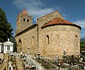
- Sainte-Marie church (11th / 12th centuries)
- Conjurador
- Tours des Cabrenç (11th / 13th centuries)
- Saint-Michel church in Cabrenys (12th century)
- Chapel of Saint-Antoine-de-Padoue (1750)
- Saint-Michel del Faig Chapel (1746)

Sainte-Marie church
View from the east

Lock of the main portal

The conjurador

One of the Tours de Cabrenç

The wash house

The rue de l'Église


Web links
Commons : Serralongue - collection of images, videos and audio files